
Source: Bureau of Meteorology
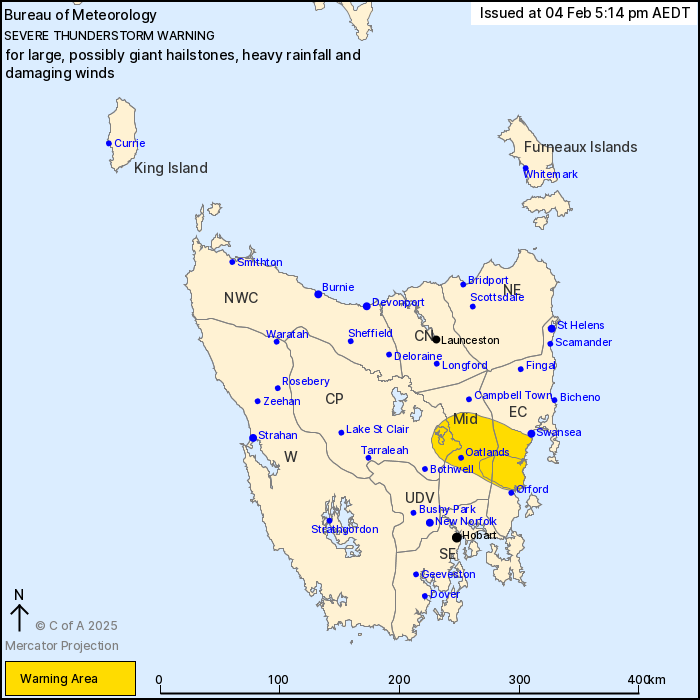
For people in parts of East Coast, Central Plateau and Midlands
Forecast Districts.
Issued at 5:14 pm Tuesday, 4 February 2025.
SEVERE THUNDERSTORMS WITH GIANT HAIL OCCURRING EAST OF
OATLANDS
Weather Situation: A southerly change is colliding with a warm and
unstable airmass to its north to produce severe thunderstorms this
afternoon over eastern Tasmania.
VERY DANGEROUS THUNDERSTORMS are likely to produce large, possibly
giant hailstones, heavy rainfall that may lead to flash flooding
and damaging winds over the next several hours in parts of the East
Coast and Midlands districts.
Severe thunderstorms are likely to produce large hailstones, heavy
rainfall that may lead to flash flooding and damaging winds over
the next several hours in parts of the East Coast, Central Plateau
and Midlands districts. Locations which may be affected include
Oatlands.
20.2 mm of rainfall was recorded at Mount Seymour in the 30
minutes till 3:13pm AEDT.
2cm hail was observed near Orford around 2:30pm AEDT.
The State Emergency Service advises that people should:
* Move your car under cover or away from trees.
* Secure loose outdoor items.
* Avoid driving, walking or riding through flood waters.
* Seek shelter, preferably indoors and never under trees.
* Avoid using the telephone during a thunderstorm.
* Beware of fallen trees and powerlines.
* For emergency assistance contact the SES on 132500.
04/Feb/2025 06:21 AM


