
Source: Bureau of Meteorology
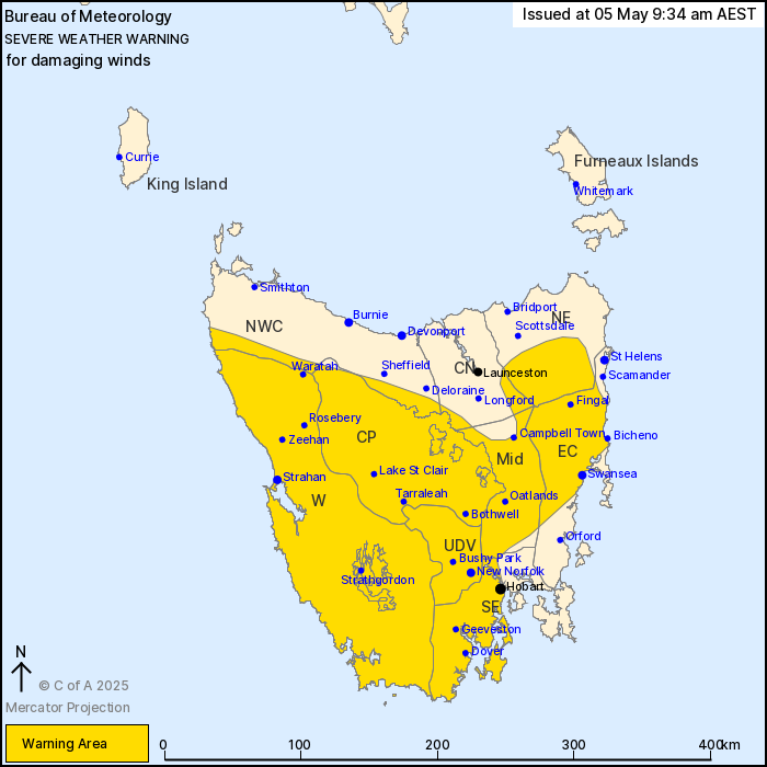
For people in Western, Upper Derwent Valley, South East, East
Coast, Central Plateau, Midlands and parts of North East, North
West Coast and Central North Forecast Districts.
Issued at 9:34 am Monday, 5 May 2025.
Damaging winds developing across Tasmania from late Monday
afternoon, easing on Tuesday morning.
Weather Situation: A cold front embedded in a vigorous
northwesterly airstream will cross the state overnight. Winds are
expected to increase ahead of and with the passage of the front,
bringing the risk of damaging winds across western and central
parts of the state from late this afternoon, particularly in
showers and thunderstorms. This risk of damaging winds extends to
eastern and southern parts of the state during the late evening and
continues into Tuesday morning.
Strong to DAMAGING WINDS of 55 to 65 km/h with peak gusts of
around of 100 km/h are expected to develop over western and central
Tasmania during the late afternoon and then extend to eastern and
southern parts of the state, including Hobart, during the late
evening. DAMAGING WIND GUSTS may reach up to 120 km/h at exposed
elevated areas.
DAMAGING WINDS are expected to ease below warning thresholds
during Tuesday morning, but winds are likely to remain gusty
throughout most of the day.
Locations which may be affected include Swansea, Bicheno, Strahan,
Queenstown, New Norfolk, Bothwell, Hobart, Geeveston and
Dover.
The State Emergency Service advises that people should:
* Supervise children closely.
* Check that family and neighbours are aware of warnings.
* Manage pets and livestock.
* Secure outdoor items including furniture and play
equipment.
* Be prepared in case of power outages and report any outages to
TasNetworks on 132 004.
* Beware of damaged trees and power lines and take care when
driving.
* Listen to the ABC radio or check www.ses.tas.gov.au for further
advice.
* For emergency assistance contact the SES on 132500.
04/May/2025 11:39 PM


