Source: Bureau of Meteorology
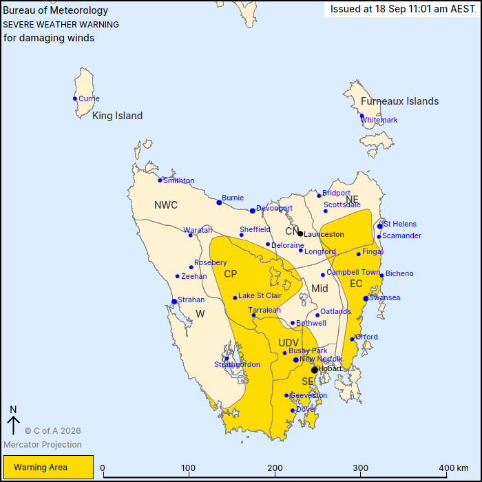
For people in Upper Derwent Valley, South East, East Coast,
Central Plateau and parts of Western, North East, North West Coast,
Central North and Midlands Forecast Districts.
Issued at 11:01 am Friday, 18 September 2026.
Damaging winds developing, extending into Hobart during this
afternoon.
Weather Situation: Westerly flow strengthens throughout Friday as
a cold front passes to the south of the state. Winds will begin to
ease late on Friday evening and into Saturday morning as the front
moves into the Tasman. Another burst of damaging winds may return
to parts of Tasmania from Sunday morning.
DAMAGING WESTERLY WINDS averaging 55 to 65 km/h with peak gusts
around 100 km/h are likely to develop Friday morning for southern
elevated areas and exposed southwest coastlines. Wind gusts may
exceed 120 km/h at elevated locations in the south. During Friday
afternoon these winds will extend over the Central Plateau and
elevated northeast, lowering into Hobart and remainder of the low
lying eastern areas by mid-afternoon.
Damaging winds are expected to ease in Hobart late Friday evening
or early Saturday morning, contracting to elevated areas only.
Damaging winds are expected to clear the state by late Saturday
morning.
Another frontal passage bringing damaging winds to parts of
Tasmania is expected from Sunday morning.
Locations which may be affected include Hobart, Swansea, New
Norfolk, Bicheno, Orford and Geeveston.
The State Emergency Service advises that people should:
* Supervise children closely.
* Check that family and neighbours are aware of warnings.
* Manage pets and livestock.
* Secure outdoor items including furniture and play
equipment.
* Be prepared in case of power outages and report any outages to
TasNetworks on 132 004.
* Beware of damaged trees and power lines and take care when
driving.
* Listen to the ABC radio or check www.ses.tas.gov.au for further
advice.
* For emergency assistance contact the SES on 132500.
18/Sep/2026 01:05 AM