
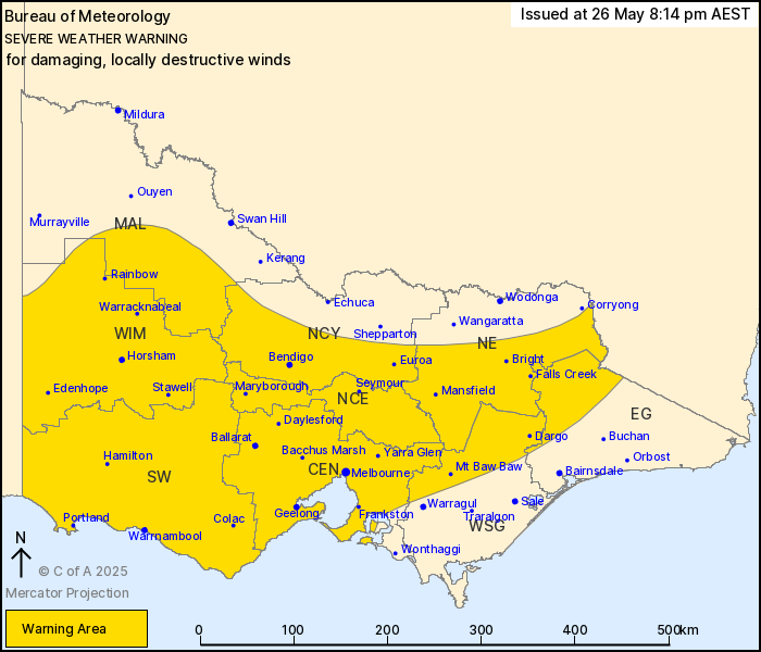
Source: Bureau of Meteorology
For people in Central, South West, North Central, Wimmera and
parts of East Gippsland, Mallee, Northern Country, North East and
West and South Gippsland Forecast Districts.
Issued at 8:14 pm Monday, 26 May 2025.
LOCALLY DESTRUCTIVE WIND GUSTS POSSIBLE OVER ALPINE PEAKS THIS
EVENING. RISK OF DAMAGING WINDS CONTINUING ELSEWHERE.
Weather Situation: Strong west to northwesterly winds associated
with a cold front are bringing a damaging wind risk to large parts
of Victoria today. Additionally, showers and thunderstorms
associated with the front also bring the risk of damaging winds to
northeastern parts of the state this evening. Winds are expected to
ease from the west behind the front later this evening, before
easing over elevated regions during Tuesday morning.
For CENTRAL RANGES AND EASTERN RANGES: DAMAGING WINDS averaging 65
to 80 km/h with peaks gusts in excess of 100 km/h are likely.
For ALPINE AREAS above 1200 m: DESTRUCTIVE WIND GUSTS with peak
gusts around 125 km/h are possible this evening.
For DANDENONG RANGES: Strong to DAMAGING winds averaging 55 to 65
km/h with peak gusts in excess of 90 km/h are possible.
Winds are expected to ease below warning thresholds over elevated
areas during Tuesday morning.
FOR WESTERN and CENTRAL VICTORIA including GREATER MELBOURNE and
GEELONG: Strong winds averaging 50 to 60 km/h with DAMAGING WIND
GUSTS in excess of 90 km/h are possible about western and central
Victoria this evening.
Winds are expected to ease below warning thresholds in the west
later this evening, and through central parts of the state by early
Tuesday morning.
A separate Severe Weather Warning for ABNORMALLY HIGH TIDES is
also current for coastal parts of the state. Please refer to
http://www.bom.gov.au/warnings/
Locations which may be affected include Horsham, Warrnambool,
Bendigo, Seymour, Maryborough, Ballarat, Geelong and
Melbourne.
125 KM/H WIND GUST WAS RECORDED AT MT HOTHAM AT 7:49 PM.
91 km/h wind gust was recorded at Mount William at 4:30 pm.
Sustained winds of 67 km/h were observed at Mount Gellibrand for a
period around 2:30 am.
Periods of sustained winds above 65 km/h at Mount Buller since
4:00 am, with a peak gust of 111 km/h.
Periods of sustained winds near or above 65 km/h at Mount Hotham
since 5:30am.
The State Emergency Service advises that people should:
* If driving conditions are dangerous, safely pull over away from
trees, drains, low-lying areas and floodwater. Avoid travel if
possible.
* Stay safe by avoiding dangerous hazards, such as floodwater,
mud, debris, damaged roads and fallen trees.
* Be aware - heat, fire or recent storms may make trees unstable
and more likely to fall when it's windy or wet.
* Check that loose items, such as outdoor settings, umbrellas and
trampolines are safely secured. Move vehicles under cover or away
from trees.
* Stay indoors and away from windows.
* If outdoors, move to a safe place indoors. Stay away from trees,
drains, gutters, creeks and waterways.
* Stay away from fallen powerlines - always assume they are
live.
* Be aware that in fire affected areas, rainfall run-off into
waterways may contain debris such as ash, soil, trees and rocks.
Heavy rainfall may also increase the potential for landslides and
debris across roads.
* Stay informed: Monitor weather warnings, forecasts and river
levels at the Bureau of Meteorology website, and warnings through
VicEmergency website/app/hotline.
26/May/2025 10:25 AM

