
Source: Bureau of Meteorology
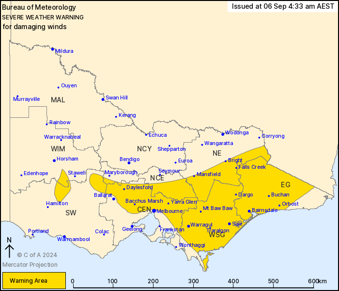
For people in East Gippsland, West and South Gippsland and parts
of Central, South West, North Central, North East and Wimmera
Forecast Districts.
Issued at 4:33 am Friday, 6 September 2024.
Damaging winds over elevated areas, expanding and increasing from
this morning.
Weather Situation: Strong north to northwesterly winds across
Victoria are increasing ahead of a cold front which is expected to
cross the State from the west today.
For the CENTRAL AND EASTERN RANGES: DAMAGING WINDS averaging 60 to
70 km/h with gusts to 110km/h are likely throughout today. Over
ALPINE AREAS above 1400m gusts to 100km/h are possible, increasing
to 120km/h this morning.
For the GRAMPIANS and PYRENEES: DAMAGING WINDS averaging 55 to 65
km/h with peak gusts of 90 to 100 km/h are expected to persist
until late morning.
For remaining areas of the CENTRAL AND GIPPSLAND DISTRICTS
including outer suburbs of MELBOURNE and GEELONG: Strong winds
averaging 50 to 60km/h with DAMAGING WIND GUSTS around 90 to
100km/h are possible this morning over inland parts, possibly
extending to parts of the Gippsland coast and STRZELECKI RANGES
after sunrise.
High based shower activity may produce sudden damaging wind gusts
at any time.
Winds should ease from the west from late morning with the passage
of the front. In the afternoon winds will ease further through
central and eastern parts of the state, as the front moves into New
South Wales from the evening.
Locations which may be affected include Morwell, Traralgon, Sale,
Moe, Bairnsdale and Orbost.
Significant observations in the 6 hours to 10:30pm AEST:
100 km/h wind gust was recorded at Mount Hotham at 1:46am
98 km/h wind gust was recorded at Mount Buller at 3:32am
The State Emergency Service advises that people should:
* If driving conditions are dangerous, safely pull over away from
trees, drains, low-lying areas and floodwater. Avoid travel if
possible.
* Stay safe by avoiding dangerous hazards, such as floodwater,
mud, debris, damaged roads and fallen trees.
* Be aware - heat, fire or recent storms may make trees unstable
and more likely to fall when it's windy or wet.
* Check that loose items, such as outdoor settings, umbrellas and
trampolines are safely secured. Move vehicles under cover or away
from trees.
* Stay indoors and away from windows.
* If outdoors, move to a safe place indoors. Stay away from trees,
drains, gutters, creeks and waterways.
* Stay away from fallen powerlines - always assume they are
live.
* Be aware that in fire affected areas, rainfall run-off into
waterways may contain debris such as ash, soil, trees and rocks.
Heavy rainfall may also increase the potential for landslides and
debris across roads.
* Stay informed: Monitor weather warnings, forecasts and river
levels at the Bureau of Meteorology website, and warnings through
VicEmergency website/app/hotline.
05/Sep/2024 08:21 PM

