AMBER THREAT
VIC Severe Weather Warning: Damaging Winds
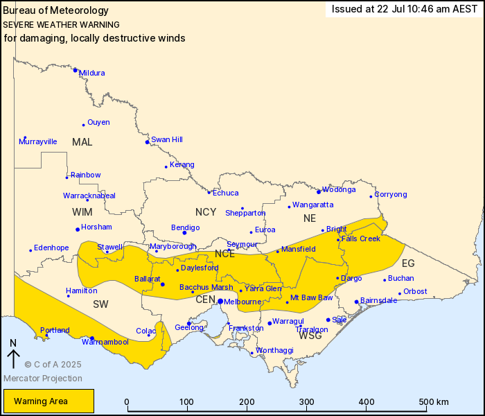
Source: Bureau of Meteorology
For people in parts of Central, East Gippsland, South West, North
Central, North East, West and South Gippsland, Wimmera and Northern
Country Forecast Districts.
Issued at 10:46 am Tuesday, 22 July 2025.
DAMAGING TO LOCALLY DESTRUCTIVE WINDS CONTINUING TODAY WITH
BLIZZARD CONDITIONS FOR ALPINE AREAS FROM LATE MORNING.
Weather Situation: A strong northerly flow ahead of an approaching
cold front is expected to produce damaging winds across central and
northeastern parts of the state this morning, and LOCALLY
DESTRUCTIVE WINDS about elevated terrain. A low pressure system
will move towards the southwest of the state this afternoon and is
also forecast to bring damaging winds. Winds expected to ease by
late this evening.
For CENTRAL and EASTERN RANGES above 1600m: DAMAGING TO LOCALLY
DESTRUCTIVE WINDS averaging 65 to 90 km/h with peak gusts up to 125
km/h are likely to continue today. Winds easing to DAMAGING WINDS
averaging 55 to 70 km/h with peak gusts of around 100 km/h during
the late afternoon, with winds easing below warning thresholds late
this evening. BLIZZARD conditions are also forecast for areas above
1600 metres from late this morning, ceasing by Tuesday
evening.
For CENTRAL and EASTERN RANGES below 1600m and the GRAMPIANS:
Strong to DAMAGING NORTHERLY WINDS averaging 50 to 65 km/h with
peak gusts of around 90 km/h are likely today, gradually easing
from the west from early afternoon in the Grampians to late evening
in the Eastern Ranges.
For the northern suburbs of MELBOURNE and the DANDENONG RANGES:
Northerly winds with DAMAGING WIND GUSTS peaking around 90 km/h are
likely from this morning before easing during the afternoon.
For the MORNINGTON PENINSULA: Strong to DAMAGING NORTHERLY WINDS
averaging 50 to 65 km/h are possible for a short period from this
morning to mid afternoon.
For the SOUTHWEST, OTWAY RANGES and SURF COAST: North to
northwesterly winds with DAMAGING WIND GUSTS peaking around 90 km/h
are possibly for the OTWAYS and SURF COAST from this morning
extending to the SOUTHWEST early this afternoon. Winds are expected
to ease early this evening.
Locations which may be affected include Ballarat, Bacchus Marsh,
Daylesford, Falls Creek, Mount Hotham, Warrnambool, Sorrento, the
Dandenong Ranges, Mt Baw Baw, and Portland.
SUSTAINED WIND SPEEDS OF 101 KM/H WERE RECORDED AT MOUNT HOTHAM
AROUND 09:30 AM.
A 150 KM/H WIND GUST WAS RECORDED AT MOUNT HOTHAM AT 08:45
AM.
A 126 KM/H WIND GUST WAS RECORDED AT MOUNT WILLIAM AT 03:55
AM.
A 91 km/h wind gust was recorded at Ballarat at 09:51 am.
A 95 km/h wind gust was recorded at Kilmore Gap at 07:56 am.
A 122 km/h wind gust was recorded at Mount Buller at 06:05
am.
A 119 km/h wind gust was recorded at Falls Creek Airport at 01:18
am.
The State Emergency Service advises that people should:
* If driving conditions are dangerous, safely pull over away from
trees, drains, low-lying areas and floodwater. Avoid travel if
possible.
* Stay safe by avoiding dangerous hazards, such as floodwater,
mud, debris, damaged roads and fallen trees.
* Be aware - heat, fire or recent storms may make trees unstable
and more likely to fall when it's windy or wet.
* Check that loose items, such as outdoor settings, umbrellas and
trampolines are safely secured. Move vehicles under cover or away
from trees.
* Stay indoors and away from windows.
* If outdoors, move to a safe place indoors. Stay away from trees,
drains, gutters, creeks and waterways.
* Stay away from fallen powerlines - always assume they are
live.
* Be aware that in fire affected areas, rainfall run-off into
waterways may contain debris such as ash, soil, trees and rocks.
Heavy rainfall may also increase the potential for landslides and
debris across roads.
* Stay informed: Monitor weather warnings, forecasts and river
levels at the Bureau of Meteorology website, and warnings through
VicEmergency website/app/hotline.