
Source: Bureau of Meteorology
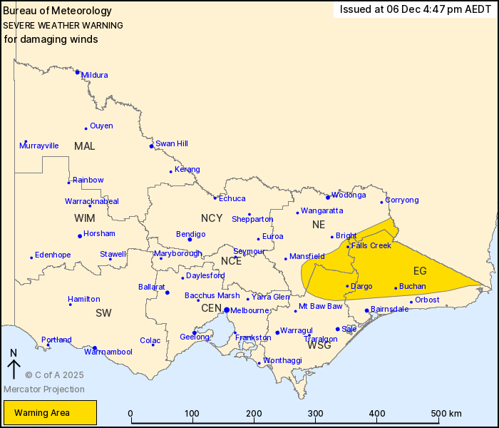
For people in East Gippsland and parts of North East and West and
South Gippsland Forecast Districts.
Issued at 4:47 pm Saturday, 6 December 2025.
Damaging winds over the eastern ranges continue, easing this
evening.
Weather Situation: A cold front traverses Victoria today. Gusty
west to northwesterly winds with this system along with gusty
showers and thunderstorms is resulting in a damaging wind risk over
the eastern ranges.
For ALPINE AREAS (above 1200 metres): Strong winds averaging 50 to
60 km/h with DAMAGING WIND GUSTS between 90 and 100 km/h are
likely, with possible isolated DAMAGING WIND GUSTS up to 110 km/h
about the alpine peaks.
For remaining areas (below 1200 metres): Strong winds averaging 50
to 60 km/h with DAMAGING WIND GUSTS of around 90 km/h are possible
across the remainder of the warning area.
DAMAGING WIND GUSTS of around 90 km/h are also possible with
showers and thunderstorms across northern and eastern Victoria this
evening. A separate Severe Thunderstorm Warning will be issued if
this occurs.
The risk of DAMAGING WIND GUSTS is expected to ease this
evening.
Locations which may be affected include Falls Creek, Dargo,
Buchan, Mt Hotham, Mt Buller and Omeo.
109 km/h was recorded at Mt Buller at 3:38 pm.
94 km/h was recorded at Mt Hotham at 6:42 am.
The State Emergency Service advises that people should:
* If driving conditions are dangerous, safely pull over away from
trees, drains, low-lying areas and floodwater. Avoid travel if
possible.
* Stay safe by avoiding dangerous hazards, such as floodwater,
mud, debris, damaged roads and fallen trees.
* Be aware - heat, fire or recent storms may make trees unstable
and more likely to fall when it's windy or wet.
* Check that loose items, such as outdoor settings, umbrellas and
trampolines are safely secured. Move vehicles under cover or away
from trees.
* Stay indoors and away from windows.
* If outdoors, move to a safe place indoors. Stay away from trees,
drains, gutters, creeks and waterways.
* Stay away from fallen powerlines - always assume they are
live.
* Be aware that in fire affected areas, rainfall run-off into
waterways may contain debris such as ash, soil, trees and rocks.
Heavy rainfall may also increase the potential for landslides and
debris across roads.
* Stay informed: Monitor weather warnings, forecasts and river
levels at the Bureau of Meteorology website, and warnings through
VicEmergency website/app/hotline.
06/Dec/2025 06:09 AM


