
Source: Bureau of Meteorology
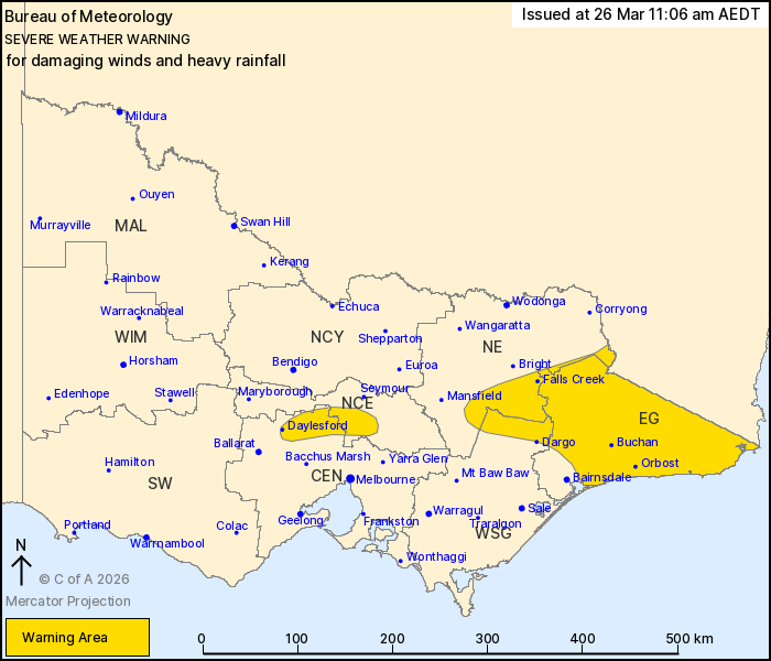
For people in East Gippsland and parts of Central, North Central,
North East and West and South Gippsland Forecast Districts.
Issued at 11:06 am Thursday, 26 March 2026.
Damaging southerly winds and heavy rainfall developing over parts
of the state on Friday.
Weather Situation: A vigorous coastal low will form offshore of
the southern NSW coast, leading to damaging southerly winds
developing over parts of the central ranges and east of the state
on Friday. Heavy rainfall is also expected to develop over parts of
East Gippsland, as these winds combine with ample moisture to rise
over topography. The low will move further offshore later on
Friday, leading to an easing of conditions across the state.
DAMAGING SOUTHERLY WIND GUSTS with peak gusts of around 90 km/h
are expected to develop over parts of the central ranges and east
on Friday morning. Wind gusts may reach 100 km/h about the East
Gippsland coast.
DAMAGING SOUTHERLY WINDS averaging 60 to 70 km/h with peak gusts
of around 100 km/h are likely about alpine areas above 1600 m from
Friday morning.
HEAVY RAINFALL which may lead to FLASH FLOODING is expected to
develop over the elevated terrain of East Gippsland on Friday
morning. Six-hourly rainfall totals between 60 to 80 mm are
likely.
Conditions are expected to ease below warning thresholds by Friday
evening.
Locations which may be affected include Orbost, Daylesford, Falls
Creek, Buchan, Kyneton and Mallacoota.
The State Emergency Service advises that people should:
* If driving conditions are dangerous, safely pull over away from
trees, drains, low-lying areas and floodwater. Avoid travel if
possible.
* Stay safe by avoiding dangerous hazards, such as floodwater,
mud, debris, damaged roads and fallen trees.
* Be aware - heat, fire or recent storms may make trees unstable
and more likely to fall when it's windy or wet.
* Check that loose items, such as outdoor settings, umbrellas and
trampolines are safely secured. Move vehicles under cover or away
from trees.
* Stay indoors and away from windows.
* If outdoors, move to a safe place indoors. Stay away from trees,
drains, gutters, creeks and waterways.
* Stay away from fallen powerlines - always assume they are
live.
* Be aware that in fire affected areas, rainfall run-off into
waterways may contain debris such as ash, soil, trees and rocks.
Heavy rainfall may also increase the potential for landslides and
debris across roads.
* Stay informed: Monitor weather warnings, forecasts and river
levels at the Bureau of Meteorology website, and warnings through
VicEmergency website/app/hotline.
26/Mar/2026 12:14 AM

