Source: Bureau of Meteorology
Refer to EmergencyWA for AWS alerts
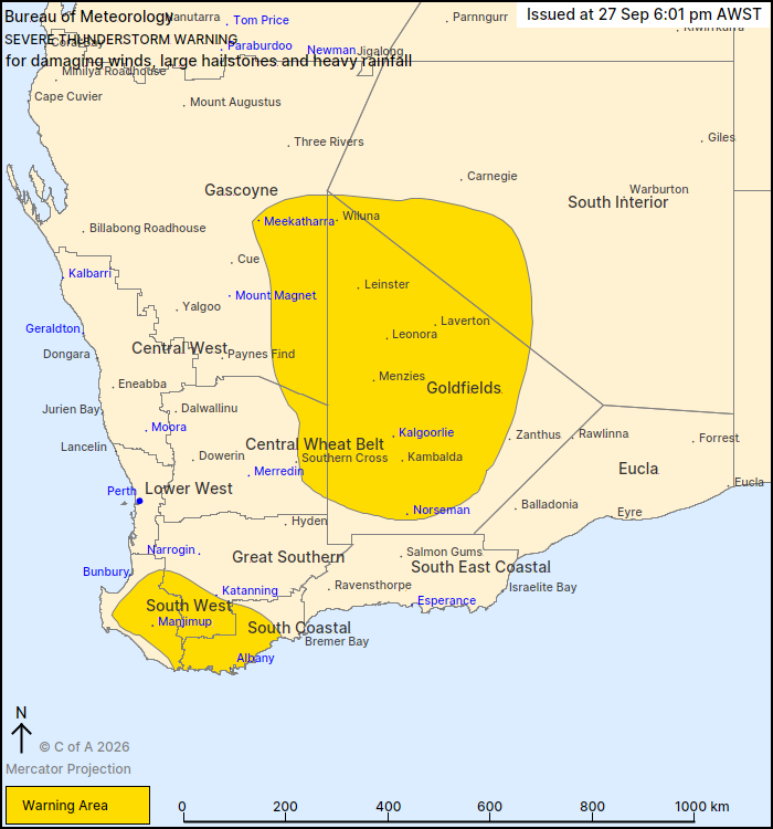
For people in Goldfields, South Coastal and parts of Gascoyne,
South Interior, South West, Great Southern and Central Wheat Belt
districts.
Issued at 6:01 pm Sunday, 27 September 2026.
Severe thunderstorms have developed about inland WA and the south
coast.
Weather Situation: Severe thunderstorms have developed east of a
surface trough in a moist and unstable environment.
Severe thunderstorms are likely to produce damaging winds, large
hailstones and heavy rainfall that may lead to flash flooding over
the next several hours in the Goldfields and parts of the Gascoyne,
South Interior and Central Wheat Belt districts. Locations which
may be affected include Kalgoorlie, Meekatharra, Norseman,
Laverton, Leinster and Leonora.
Severe thunderstorms are likely to produce heavy rainfall that may
lead to flash flooding over the next several hours in the South
Coastal and parts of the South West and Great Southern districts.
Locations which may be affected include Albany, Manjimup, Mount
Barker, Collie, Walpole and Bridgetown.
The Department of Fire and Emergency Services advises that people
should:
* If outside find safe shelter away from trees, power lines, storm
water drains and streams.
* Close your curtains and blinds, and stay inside away from
windows.
* Unplug electrical appliances and do not use land line telephones
if there is lightning.
* If there is flooding, create your own sandbags by using pillow
cases filled with sand and place them around doorways to protect
your home.
* If boating, swimming or surfing leave the water.
* Do not drive into water of unknown depth and current.
* Slow down and turn your headlights on.
* Be alert and watch for hazards on the road such as fallen power
lines and loose debris.
* If it is raining heavily and you cannot see, pull over and park
with your hazard lights on until the rain clears.
27/Sep/2026 10:05 AM