
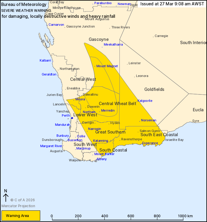
Source: Bureau of Meteorology
For people in South East Coastal, Great Southern, Central Wheat
Belt and parts of Gascoyne, Goldfields, Central West, Lower West,
South Coastal and Eucla districts.
Issued at 9:08 am Friday, 27 March 2026.
DAMAGING TO LOCALLY DESTRUCTIVE WIND GUSTS AND HEAVY RAINFALL
POSSIBLE FOR PARTS OF SOUTH WEST LAND DIVISION SATURDAY.
Weather Situation: Severe Tropical Cyclone Narelle is currently
located near Coral Bay and will maintain a southerly track near the
Gascoyne coast during Friday. The system is forecast to transition
to a vigorous subtropical low on Saturday morning as it moves more
rapidly to the southeast, with the risk of damaging winds and heavy
rainfall continuing through Saturday as the system passes through
southwestern districts before moving off the south coast on
Saturday evening.
DESTRUCTIVE WINDS averaging 80 to 90 km/h with DESTRUCTIVE GUSTS
in excess of 125 km/h are possible near the system in the northern
part of the warning area during Saturday morning and may cause
SIGNIFICANT DAMAGE TO HOMES AND PROPERTY.
DAMAGING WINDS averaging 65 to 75 km/h with peak gusts of around
100 km/h are likely over other northern parts of the warning area
on Saturday morning, with DAMAGING WIND GUSTS to 100 km/h likely to
shift southwards over the remainder of the warning area during
Saturday afternoon and evening.
HEAVY RAINFALL which may lead to FLASH FLOODING is forecast for
parts of the Gascoyne, Central West, Lower West and Central Wheat
Belt districts during Saturday morning and afternoon. Six-hour
rainfall totals between 30 and 50 mm are likely, with isolated
totals of around 70 mm possible mainly in the north of the warning
area.
Conditions are likely to ease below warning thresholds by early
Sunday morning as the system moves offshore.
A Tropical Cyclone Advice remains in place for Severe Tropical
Cyclone Narelle. A Flood Watch is also current for the area. Refer
to www.bom.gov.au/weather-and-climate/warnings-and-alerts for the
latest information.
Locations which may be affected include Esperance, Kalgoorlie,
Katanning, Merredin, Moora, Mount Magnet, Narrogin, Norseman and
Northam.
The Department of Fire and Emergency Services advises that people
should:
* If outside find safe shelter away from trees, power lines, storm
water drains and streams.
* Close your curtains and blinds, and stay inside away from
windows.
* Unplug electrical appliances and do not use land line telephones
if there is lightning.
* If boating, swimming or surfing leave the water.
* Be alert and watch for hazards on the road such as fallen power
lines and loose debris.
* Keep away from flooded drains, rivers, streams and
waterways.
* Be careful of fallen trees, damaged buildings and debris.
* Be careful of fallen power lines. They are dangerous and should
always be treated as live.
* Assess your home, car and property for damage.
* If damage has occurred take photos and contact your insurance
company to organise permanent repairs.
* If your home or property has significant damage, like a badly
damaged roof or flooding, call the SES on 132 500.
27/Mar/2026 01:14 AM

