
Source: Bureau of Meteorology
TROPICAL CYCLONE ADVICE NUMBER 63
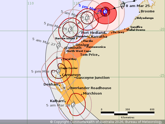
Issued at 5:51 pm WST on Wednesday 25 March 2026
Headline:
Severe Tropical Cyclone Narelle has strengthened to category 3.
Potential
severe impacts for the west Pilbara and Gascoyne coasts.
Areas Affected:
Warning zone: Sandfire to Coral Bay, including Port Hedland,
Karratha, Onslow
and Exmouth, and extending inland to Pannawonica.
Watch zone: Coral Bay to Kalbarri, including Carnarvon and Denham,
and
extending inland to Gascoyne Junction and Murchison.
Cancelled zone: None.
Details of Severe Tropical Cyclone Narelle 34U at 5:00 pm
AWST:
Intensity: Category 3, sustained winds near the centre of 120
kilometres per
hour with wind gusts to 165 kilometres per hour.
Location: within 35 kilometres of 17.9 degrees South 118.5 degrees
East,
estimated to be 270 kilometres north of Port Hedland and 360
kilometres north
northeast of Karratha.
Movement: west southwest at 22 kilometres per hour.
Severe Tropical Cyclone Narelle is now a Category 3 tropical
cyclone and is
expected to continue to strengthen.
Narelle is moving west southwest, roughly parallel to the Pilbara
coast.
Narelle is larger than usual and although the cyclone is located
well north of
the Pilbara, gales are likely to extend to the coast this
evening.
On Friday, Narelle will turn towards the south, likely passing
close to the
North West Cape as a Category 4 system.
There is the potential for a severe impact on the far western
Pilbara coast
from late Thursday, extending south to Denham during Friday.
On Saturday Narelle is expected to be weakening as it moves
quickly to the
south southeast with impacts extending to the Central West and
then further
inland and south across the South West Land Division.
Hazards:
VERY DESTRUCTIVE WIND GUSTS up to 260 km/h may develop west of
Onslow later on
Thursday as Narelle moves closer to the North West Cape, and
possibly extend
south to Carnarvon during Friday. Wind gusts to 195 km/h may
extend south to
Denham later Friday.
DESTRUCTIVE WIND GUSTS in excess of 125 km/h may develop on the
Pilbara coast
near Karratha early Thursday, extending west to Exmouth during
Thursday, and
south to Carnarvon and then to Denham and the Overlander Roadhouse
during
Friday.
GALES with DAMAGING WIND GUSTS to 100 km/h are possible between
Sandfire and
Port Hedland, extending west to Dampier tonight. GALES with
DAMAGING WIND GUSTS
to 120 km/h may develop west to Exmouth during Thursday and extend
further
south to Kalbarri and inland to the Murchison Roadhouse during
Friday.
Coastal residents between Onslow and Denham are specifically
warned of a
DANGEROUS STORM TIDE as the cyclone moves south down the Gascoyne
coast. Tides
are likely to rise significantly above the normal high tide, with
DAMAGING
WAVES and DANGEROUS FLOODING.
Tides will be higher than normal between Port Hedland and Onslow.
LARGE WAVES
may produce MINOR FLOODING of low-lying coastal areas.
Recommended Action:
DFES advises:
Ensure you know what to do in a cyclone. For the latest DFES
community alerts
and warnings visit www.emergency.wa.gov.au or download the
Emergency WA app.
Current
Tropical Cyclones
25/Mar/2026 10:30 AM

