
Source: Bureau of Meteorology
TROPICAL CYCLONE ADVICE NUMBER 59
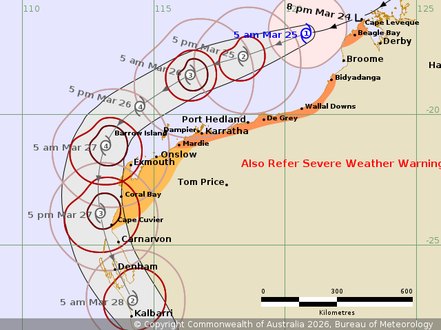
Issued at 5:58 am WST on Wednesday 25 March 2026
Headline:
Tropical Cyclone Narelle has redeveloped into a tropical cyclone
and is moving away from the Kimberley coast.
Areas Affected:
Warning Zone
Cape Leveque to south of Beagle Bay, and Bidyadanga to Mardie,
including Port Hedland and Karratha.
Watch Zone
Mardie to Cape Cuvier, including Onslow, Exmouth and Coral
Bay.
Cancelled Zone
None.
Details of Tropical Cyclone Narelle 34U at 5:00 am AWST:
Intensity: Category 1, sustained winds near the centre of 75
kilometres per hour with wind gusts to 100 kilometres per
hour.
Location: within 35 kilometres of 16.9 degrees South 120.8 degrees
East, estimated to be 195 kilometres northwest of Broome and 445
kilometres north northeast of Port Hedland.
Movement: west southwest at 23 kilometres per hour.
Tropical Cyclone Narelle has redeveloped into a Category 1
tropical cyclone.
Narelle will continue moving to the west southwest, roughly
parallel to the Pilbara coast during today and Thursday, and is
forecast to reach severe (category 3) intensity late Wednesday or
early Thursday. During this time gales may extend to the coast
while Narelle remains over waters to the north of the
Pilbara.
Later on Thursday and during Friday, Narelle will turn towards the
south, likely passing close to the North West Cape. During this
time impacts may extend to the inland western Pilbara and along the
Ningaloo coast. Narelle will move to the south southeast during
Friday and Saturday, with impacts extending along the Gascoyne
coast and expected as far south as the Lower West on the
weekend.
Hazards:
GALES with DAMAGING WIND GUSTS to 90 km/h are possible in coastal
parts of the Dampier Peninsula north of Broome overnight, including
Beagle Bay and Cape Leveque, before gradually easing during
Wednesday morning as Narelle moves further away from the west
Kimberley coast. A Severe Weather Warning for showers with damaging
wind gusts is in place over parts of far west Kimberley.
GALES with DAMAGING WIND GUSTS to 100 km/h may develop along the
coast between Bidyadanga and De Grey during Wednesday morning.
Gales are forecast to extend further west along the Pilbara coast
to Port Hedland and Karratha later Wednesday. GALES with DAMAGING
WIND GUSTS to 120 km/h may develop west to Exmouth during Thursday
afternoon and extend further south to Cape Cuvier by Friday
morning.
DESTRUCTIVE WIND GUSTS to 140 km/h may develop on the Pilbara
coast near Karratha late Wednesday or early Thursday, extending to
Exmouth during Thursday, and to Coral Bay by early Friday.
Isolated HEAVY RAINFALL which may lead to FLASH FLOODING may occur
across parts of the north and west Kimberley during
Wednesday.
Tides will be higher than normal between Port Hedland and North
West Cape. LARGE WAVES may produce MINOR FLOODING of low-lying
coastal areas.
Recommended Action:
DFES advises:
Ensure you know what to do in a cyclone. For the latest DFES
community alerts and warnings visit www.emergency.wa.gov.au or
download the Emergency WA app.
Current
Tropical Cyclones
24/Mar/2026 10:04 PM

