
Source: Bureau of Meteorology
Issued at 6:58 pm WST on Friday 27 March 2026
Headline:
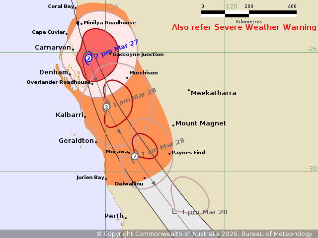
Tropical Cyclone Narelle is located inland to the southeast of
Carnarvon and weakening.
Areas Affected:
Warning Zone
Coral Bay to Jurien Bay, including Carnarvon, Denham and
Geraldton, and extending inland to Murchison and Dalwallinu.
Watch Zone
None.
Cancelled Zone
None.
Details of Tropical Cyclone Narelle 34U at 7:00 pm AWST:
Intensity: Category 2, sustained winds near the centre of 110
kilometres per hour with wind gusts to 155 kilometres per
hour.
Location: within 30 kilometres of 25.2 degrees South 114.3 degrees
East, estimated to be 75 kilometres east southeast of Carnarvon and
110 kilometres northeast of Denham.
Movement: south southeast at 36 kilometres per hour.
Narelle lies over the Gascoyne southeast of Carnarvon and is
weakening as it moves quickly south-southeast.
On Saturday, the system is expected to continue tracking quickly
south-southeast over land while weakening further. Impacts will
extend into the Central West, before spreading further inland and
south across the South West Land Division. The strongest winds are
expected to remain on the eastern side of the system.
Hazards:
DESTRUCTIVE WIND GUSTS in excess of 125 km/h extend from Minilya
Roadhouse to Overlander Roadhouse and inland to Gascoyne Junction.
DESTRUCTIVE WIND GUSTS in excess of 125 km/h are expected to extend
south and may reach inland parts of the Central West and adjacent
western Gascoyne overnight, and possibly as far south as Morawa
early Saturday morning.
GALES with DAMAGING WIND GUSTS to 120 km/h are occurring in
coastal areas between Coral Bay and south of Overlander Roadhouse
and adjacent inland areas to Murchison. Gales will extend south to
Kalbarri and inland overnight, and south to Jurien Bay and inland
to Dalwallinu during early Saturday morning.
HEAVY RAINFALL which may lead to FLASH FLOODING is possible over
western parts of the Pilbara, Gascoyne and Central West overnight.
Areas of INTENSE RAINFALL that may lead to SEVERE FLASH FLOODING
are possible through central and southern parts of the Gascoyne
overnight.
Tides between Exmouth and Denham are likely to rise above the
normal high tide mark with LARGE WAVES and MINOR FLOODING of
low-lying coastal areas.
A Severe Weather Warning is also current for damaging to locally
destructive winds and heavy rainfall on Saturday across much of
southwest WA east of Perth and northeast of Albany.
Recommended Action:
DFES advises:
Ensure you know what to do in a cyclone. For the latest DFES
community alerts and warnings visit www.emergency.wa.gov.au or
download the Emergency WA app.
Current
Tropical Cyclones
27/Mar/2026 11:05 AM

