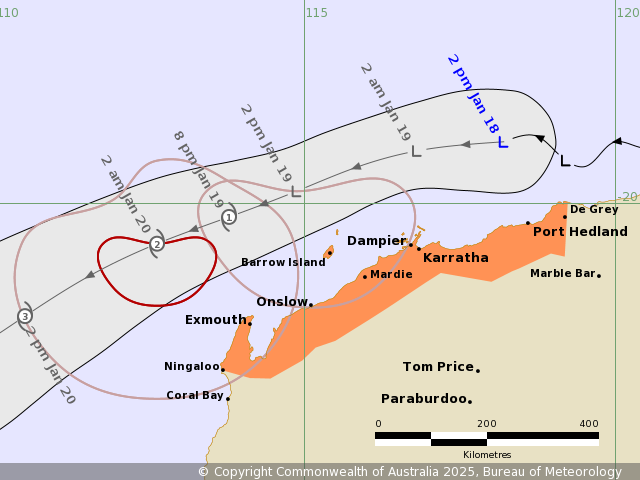
Source: Bureau of Meteorology
Issued at 2:45 pm WST on Saturday 18 January 2025
Headline:
Gale-force winds expected along the Pilbara coast as tropical
cyclone develops.
Areas Affected:
Warning zone: De Grey to Ningaloo, including Port Hedland,
Karratha, Dampier, Onslow and Exmouth.
Watch zone: None.
Cancelled zone: None.
Details of Tropical Low 11U at 2:00 pm AWST:
Intensity: Tropical Low, sustained winds near the centre of 55
kilometres per hour with wind gusts to 85 kilometres per
hour.
Location: within 95 kilometres of 19.0 degrees South 118.2 degrees
East, estimated to be 150 kilometres north northwest of Port
Hedland and 240 kilometres northeast of Karratha.
Movement: west at 16 kilometres per hour.
A tropical low north of the Pilbara coast is expected to develop
into a tropical cyclone on Sunday. The developing low is expected
to move west, parallel to the Pilbara coast tonight and on Sunday.
From Monday, the cyclone is expected to be moving southwest and
away from the WA coast.
Hazards:
GALES with DAMAGING WIND GUSTS may develop about coastal and
island communities between De Grey and Dampier including Port
Hedland, Karratha and Dampier from early Sunday morning, extending
west to Mardie later Sunday morning, Exmouth Sunday evening and to
Ningaloo early Monday.
As the system moves westwards, parallel to north WA coast during
the weekend, a storm tide is expected between De Grey and Exmouth
during Sunday and Monday.
Large waves may produce minor flooding along the foreshore. People
living in areas likely to be affected by this flooding should take
measures to protect their property as much as possible and be
prepared to help their neighbours.
Recommended Action:
Ensure you know what to do in a cyclone. For the latest DFES
community alerts and warnings visit emergency.wa.gov.au or download
the Emergency WA app.
Current
Tropical Cyclones

18/Jan/2025 07:01 AM


