
Source: Bureau of Meteorology
Issued at 5:49 am WST on Saturday 7 February 2026
Headline:
Tropical Cyclone Mitchell (21U) is intensifying, with hazardous
conditions expected for the Pilbara coast later today.
Areas Affected:
Warning zone: De Grey to Ningaloo, including Port Hedland,
Karratha, Onslow, and Exmouth, and extending inland through the
western Pilbara to include Pannawonica.
Watch zone: Coral Bay to Carnarvon, including adjacent inland
areas.
Cancelled zone: None.
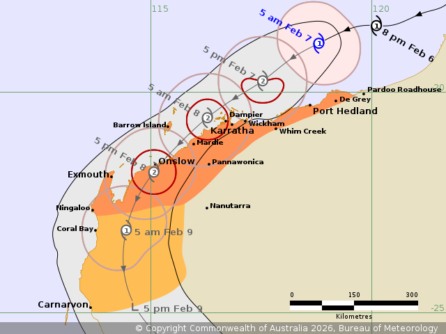
Details of Tropical Cyclone Mitchell 21U at 5:00 am AWST:
Intensity: Category 1, sustained winds near the centre of 85
kilometres per hour with wind gusts to 120 kilometres per
hour.
Location: within 55 kilometres of 18.9 degrees South 118.8 degrees
East, estimated to be 160 kilometres north of Port Hedland and 290
kilometres northeast of Karratha.
Movement: west southwest at 15 kilometres per hour.
Tropical Cyclone Mitchell (21U) lies to the north of Port Hedland
and is expected to intensify further. It is forecast to reach
category 2 cyclone later today.
Mitchell is moving to the west southwest and is expected to remain
off the coast initially. It will most likely begin a gradual turn
towards the southwest, and the Pilbara coast, from tonight, most
likely making landfall over the western Pilbara coast during Sunday
afternoon.
If Mitchell moves slower and remains offshore for longer, there is
a slight possibility that it intensifies to a category 3 cyclone
during Saturday night.
Hazards:
DESTRUCTIVE WIND GUSTS to 150 km/h may occur over the coastal
parts of the Pilbara around Karratha, Dampier and Wickham from this
evening, extending to Mardie tonight. Destructive winds may extend
further west along the coast towards Onslow and Exmouth during
Sunday as the destructive core of Mitchell approaches the
coast.
GALES with DAMAGING WIND GUSTS to 120 km/h are possible along the
coastal parts between De Grey and Mardie during Saturday, extending
west to Onslow and Exmouth and through inland parts of the western
Pilbara, including Pannawonica, from early Sunday morning.
Widespread moderate to locally HEAVY RAINFALL which may lead to
FLASH FLOODING is possible from later today with this risk
persisting through the weekend for the Pilbara coast.
Tides between Wickham and Exmouth are likely to rise above the
normal high tide mark on Saturday and Sunday and LARGE WAVES may
produce FLOODING of low-lying coastal areas.
Recommended Action:
Ensure you know what to do in a cyclone. For the latest DFES
community alerts and warnings visit www.emergency.wa.gov.au or
download the Emergency WA app.
Current
Tropical Cyclones
06/Feb/2026 09:57 PM

