
Source: Bureau of Meteorology
Issued at 11:54 am WST on Thursday 17 April 2025
Headline:
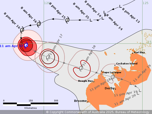
Severe Tropical Cyclone Errol is weakening and now tracking to the
east southeast, towards the west Kimberley coast.
Areas Affected:
Warning Zone
Kuri Bay to Broome, not including Broome .
Watch Zone
None.
Cancelled Zone
None.
Details of Severe Tropical Cyclone Errol 29U at 11:00 am
AWST:
Intensity: Category 4, sustained winds near the centre of 165
kilometres per hour with wind gusts to 230 kilometres per
hour.
Location: within 30 kilometres of 15.1 degrees South 119.1 degrees
East, estimated to be 465 kilometres northwest of Broome and 495
kilometres west northwest of Cockatoo Island.
Movement: east southeast at 6 kilometres per hour.
Severe Tropical Cyclone Errol is Category 4 and has started to
move to the east southeast over the last 3 hours. It will continue
on the east southeast track towards the west Kimberley coast during
today and Friday.
Errol has started weakening and is expected to quickly weaken
further, decreasing in strength to Category 2 early Friday, then to
Category 1 later Friday as it brushes the tip of the Dampier
Peninsula. It is forecast to weaken below tropical cyclone strength
as it crosses the Kimberley coast overnight Friday most likely
between Cape Leveque and Cockatoo Island, north of Derby.
Hazards:
Gales with DAMAGING WIND GUSTS may develop between Cockatoo Island
and Beagle Bay from Friday morning, and may extend to Kuri Bay
Friday evening and overnight Friday. Gales with DAMAGING WIND GUSTS
could extend southwards from Beagle Bay to Broome during Friday,
only if the track shifts south of its current forecast.
DESTRUCTIVE WIND GUSTS of up to 140 kilometres per hour may
develop between Cockatoo Island to Beagle Bay from about the middle
of the day, but only if Errol does not weaken as quickly as
forecast.
Isolated HEAVY RAINFALL may develop between Kuri Bay and Broome
during Friday and persist during Saturday morning as Errol moves
closer to and crosses the west Kimberley coast.
Tides may rise above the normal high tide mark, but sea levels
should not exceed the highest tide of the year.
Recommended Action:
DFES advises: Ensure you know what to do in a cyclone. For the
latest DFES community alerts and warnings visit
www.emergency.wa.gov.au or download the Emergency WA app.
Current
Tropical Cyclones
17/Apr/2025 04:06 AM


