
Source: Bureau of Meteorology
Issued at 8:52 am WST on Monday 29 December 2025
Headline:
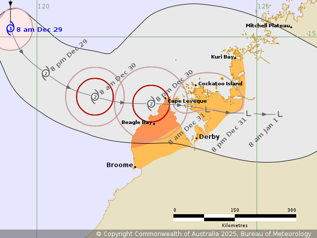
Tropical Cyclone Hayley to impact the Dampier Peninsula on the
west Kimberley coast during Tuesday.
Areas Affected:
Warning Zone
north of Broome to Cape Leveque.
Watch Zone
Broome to Kuri Bay, including Derby.
Cancelled Zone
None.
Details of Tropical Cyclone Hayley 08U at 8:00 am AWST:
Intensity: Category 1, sustained winds near the centre of 85
kilometres per hour with wind gusts to 120 kilometres per
hour.
Location: within 45 kilometres of 14.8 degrees South 119.4 degrees
East, estimated to be 465 kilometres northwest of Broome and 420
kilometres west northwest of Cape Leveque.
Movement: south at 10 kilometres per hour.
Tropical Cyclone Hayley currently well northwest of the Kimberley
coast and is strengthening as it moves south.
Hayley is forecast to turn to the southeast later today towards
the western Kimberley coast. It is forecast to turn more easterly
during Tuesday towards the Dampier Peninsula.
At this stage a category 2 impact is forecast although Hayley
should begin to weaken as it nears the coast.
Hazards:
GALES with DAMAGING WIND GUSTS to 100 km/h may develop over the
Dampier Peninsula north of Broome as early as late Tuesday morning.
Gales may extend further east to Cockatoo Island overnight Tuesday
and possibly further east to Kuri Bay early Wednesday.
DESTRUCTIVE WIND GUSTS to 140 km/h are possible about the coast
north of Broome to Cape Leveque from Tuesday evening.
HEAVY RAINFALL which may lead to FLASH FLOODING is possible near
the track for the area under Warning and Watch from Tuesday.
Tides will be higher than normal as Hayley approaches the west
Kimberley Coast.
Recommended Action:
DFES Advises: Ensure you know what to do in a cyclone. For the
latest DFES community alerts and warnings visit
www.emergency.wa.gov.au or download the Emergency WA app.
Current
Tropical Cyclones
29/Dec/2025 01:03 AM

