
Source: Bureau of Meteorology
TROPICAL CYCLONE ADVICE NUMBER 51
Issued at 11:50 am WST on Monday 24 November 2025
Headline:
Severe Tropical Cyclone Fina, category 4, is impacting the
northeast Kimberley coast.
Areas Affected:
Warning Zone
NT/WA Border to east of Kalumburu.
Watch Zone
None.
Cancelled Zone
None.
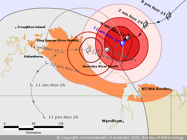
Details of Severe Tropical Cyclone Fina 02U at 11:00 am
AWST:
Intensity: Category 4, sustained winds near the centre of 195
kilometres per hour with wind gusts to 270 kilometres per
hour.
Location: within 20 kilometres of 14.0 degrees South 128.1 degrees
East, estimated to be 60 kilometres northeast of Berkeley River
Mouth and 160 kilometres east of Kalumburu.
Movement: southwest at 6 kilometres per hour.
Fina remains a category 4 cyclone as it tracks southwest across
the southern Joseph Bonaparte Gulf. Fina has begun to affect the
northeast Kimberley coast near Berkeley River Mouth.
The very destructive core of Severe Tropical Cyclone Fina is
forecast to cross the coast most likely between King George River
Mouth and Berkeley River Mouth later this afternoon or
evening.
Hazards:
GALES with DAMAGING WIND GUSTS to 120 km/h are occurring along the
coast between King George River Mouth and the WA/NT Border,
extending inland to the east of Kalumburu later today.
DESTRUCTIVE WIND GUSTS to 155 km/h are occurring along the
northeast Kimberley coast, extending to areas including King George
River Mouth and Berkeley River Mouth. These conditions are expected
to ease early Tuesday as Fina weakens over land.
VERY DESTRUCTIVE WIND GUSTS to 185 km/h may develop over the
coastal areas between King George River Mouth and Berkeley River
Mouth this afternoon as Fina approaches the coast.
HEAVY to LOCALLY INTENSE RAINFALL, which may lead to FLASH
FLOODING, is developing about the northeast Kimberley coast and is
expected to then ease later on Tuesday.
Coastal residents between King George River Mouth and the WA/NT
Border may see tides rise above the normal high tide mark during
today. LARGE WAVES may produce MINOR FLOODING of low-lying coastal
areas.
Current
Tropical Cyclones
24/Nov/2025 04:12 AM

