
Source: Bureau of Meteorology
TROPICAL CYCLONE ADVICE NUMBER 43
Issued at 9:50 pm WST on Sunday 8 February 2026
Headline:
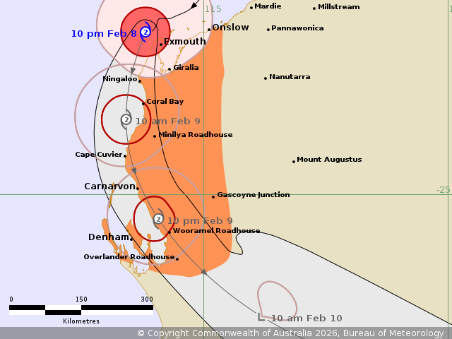
Tropical Cyclone Mitchell (21U), category 2, currently located
near the North West Cape impacting the Onslow and Exmouth regions.
Forecast to move down the Ningaloo and Gascoyne coasts towards
Carnarvon on Monday.
Areas Affected:
Warning Zone
Onslow to Overlander Roadhouse, including Exmouth, Carnarvon, and
Denham, and extending inland through the western Pilbara and
western Gascoyne including Gascoyne Junction.
Watch Zone
None.
Cancelled Zone
None.
Details of Tropical Cyclone Mitchell 21U at 10:00 pm AWST:
Intensity: Category 2, sustained winds near the centre of 110
kilometres per hour with wind gusts to 155 kilometres per
hour.
Location: within 30 kilometres of 21.7 degrees South 113.8 degrees
East, estimated to be 135 kilometres west of Onslow and 45
kilometres northwest of Exmouth.
Movement: southwest at 17 kilometres per hour.
Tropical Cyclone Mitchell (21U), a category 2 cyclone, is expected
to maintain its strength as it moves southwest towards the North
West Cape this evening. Mitchell will then move south near the
Ningaloo and Carnarvon coasts on Monday.
Hazards:
DESTRUCTIVE WIND GUSTS to 155 km/h are likely occurring over
northern parts of the North West Cape, including Exmouth.
Destructive wind gusts may extend south down the coast to Coral Bay
on Monday morning, and then possibly further south to Carnarvon on
Monday afternoon.
GALES with DAMAGING WIND GUSTS to 120 km/h are occurring about
remaining coastal areas from Onslow to Ningaloo. GALES with
DAMAGING WIND GUSTS to 120 km/h are forecast to extend further
south to Coral Bay and inland parts of the western Pilbara and far
northern Gascoyne tonight. During Monday, GALES should extend
further south through the western Gascoyne, developing over
Carnarvon in the afternoon and possibly to Denham, Wooramel,
Overlander Roadhouse, and Gascoyne Junction during the
evening.
Localised moderate to HEAVY RAINFALL which may lead to FLASH
FLOODING is possible over the west Pilbara coast, extending to the
west Gascoyne region on Monday.
ABNORMALLY HIGH TIDES are expected to rise above the normal high
tide mark along the far west Pilbara coast including Exmouth on
Monday early morning's high tide, and at Coral Bay on Monday
afternoon's high tide causing FLOODING of low-lying coastal areas.
ABNORMALLY HIGH TIDES are expected along the Gascoyne coast,
including Carnarvon on Monday afternoon's high tide and possibly
further south to Denham overnight Monday.
Recommended Action:
Ensure you know what to do in a cyclone. For the latest DFES
community alerts and warnings visit www.emergency.wa.gov.au or
download the Emergency WA app.
Current
Tropical Cyclones
08/Feb/2026 01:54 PM


