
Source: Bureau of Meteorology
Transmitters serving the Karratha to Onslow areas, including
Mardie, are requested to USE the Standard Emergency Warning Signal
before broadcasting the following warning.
TOP PRIORITY FOR IMMEDIATE BROADCAST
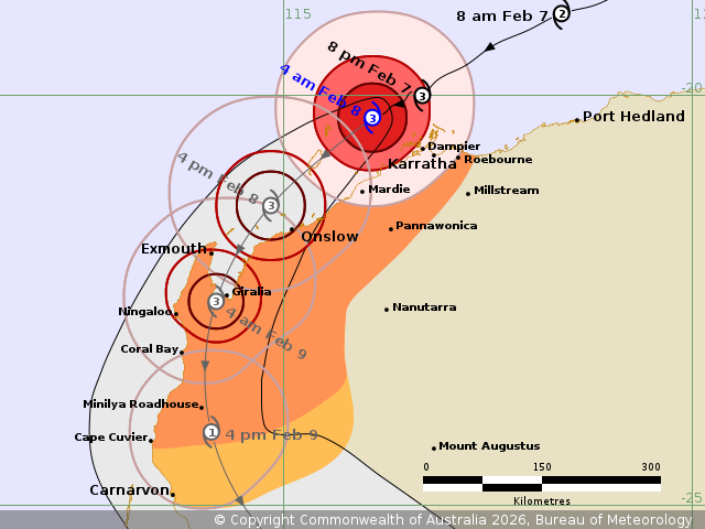
TROPICAL CYCLONE ADVICE NUMBER 25
Issued at 4:01 am WST on Sunday 8 February 2026
Headline:
Severe Tropical Cyclone Mitchell (21U) is to the northwest of
Dampier and moving southwest.
Areas Affected:
Warning Zone
Roebourne to Cape Cuvier, including Karratha, Onslow, and Exmouth,
and extending inland through the western Pilbara to include
Pannawonica.
Watch Zone
South of Cape Cuvier to Carnarvon, and adjacent inland
areas.
Cancelled Zone
None.
Details of Severe Tropical Cyclone Mitchell 21U at 4:00 am
AWST:
Intensity: Category 3, sustained winds near the centre of 140
kilometres per hour with wind gusts to 195 kilometres per
hour.
Location: within 30 kilometres of 20.3 degrees South 116.1 degrees
East, estimated to be 95 kilometres west northwest of Karratha and
185 kilometres northeast of Onslow.
Movement: west southwest at 12 kilometres per hour.
Severe Tropical Cyclone Mitchell (21U) is at category 3 intensity
and is expected to maintain its strength as it continues to move
towards the southwest during Sunday morning.
Mitchell is forecast to move closer to Onslow during Sunday
afternoon while remaining over water, with landfall possible
between Exmouth and Onslow later Sunday, possibly early Monday
morning if Mitchell tracks south over the Exmouth Gulf.
Hazards:
VERY DESTRUCTIVE WIND GUSTS to 195 km/h are possible along the
coast west of Dampier to Mardie this morning if Mitchell takes a
more southerly track, extending to Onslow during the day. Very
destructive wind gusts may develop close to coast near Onslow in
the afternoon and extend along the coast to Exmouth as the core of
Mitchell approaches in the evening.
DESTRUCTIVE WIND GUSTS to 160 km/h are possible to the west of
Dampier to Cape Preston this morning, extending westwards along the
coast towards Onslow during the day, and later extending to Exmouth
in the evening.
GALES with DAMAGING WIND GUSTS to 120 km/h are occurring along
coastal areas between Roebourne and Mardie, possibly extending
inland to Pannawonica later on Sunday morning. GALES with DAMAGING
WIND GUSTS to 120 km/h are forecast to extend west to Onslow and
Exmouth on Sunday afternoon and evening, and then extend further
south to Cape Cuvier and inland parts of the western Pilbara on
Sunday night.
Widespread moderate to HEAVY RAINFALL which may lead to FLASH
FLOODING is likely over the west Pilbara coast, extending to the
west Gascoyne region on Monday. Local areas of INTENSE rainfall
leading to SEVERE FLASH FLOODING may occur around the west Pilbara
coast around Onslow.
ABNORMALLY HIGH TIDES are expected along the west Pilbara coast,
including Onslow and Exmouth. Tides are likely to rise above the
normal high tide mark on Sunday afternoon and Monday morning high
tide mark causing FLOODING of low-lying coastal areas.
Recommended Action:
Ensure you know what to do in a cyclone. For the latest DFES
community alerts and warnings visit www.emergency.wa.gov.au or
download the Emergency WA app.
Next Advice:
The next advice will be issued by 5:00 am AWST Sunday 08
February.
Cyclone advices and DFES Alerts are available by dialling 13 DFES
(13 3337)
Current
Tropical Cyclones
07/Feb/2026 08:15 PM


