Source: Bureau of Meteorology
TROPICAL CYCLONE ADVICE NUMBER 54
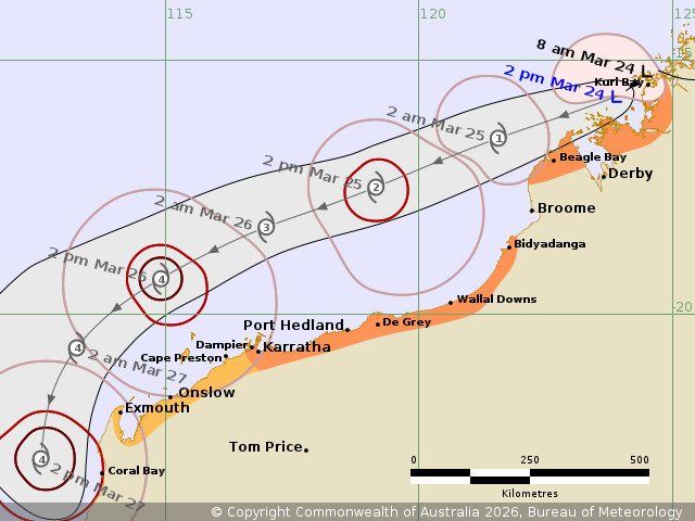
Issued at 2:53 pm WST on Tuesday 24 March 2026
Headline:
Ex-Tropical Cyclone Narelle expected to redevelop into a tropical
cyclone tonight and move roughly parallel to the Pilbara coast on
Wednesday and Thursday.
Areas Affected:
Warning Zone
South of Beagle Bay to Kuri Bay, and Dampier to Bidyadanga,
including Dampier, Karratha and Port Hedland.
Watch Zone
Exmouth to Dampier, including Exmouth and Onslow.
Cancelled Zone
None.
Details of Ex-Tropical Cyclone Narelle 34U at 2:00 pm
AWST:
Intensity: Tropical Low, sustained winds near the centre of 65
kilometres per hour with wind gusts to 95 kilometres per
hour.
Location: within 35 kilometres of 15.7 degrees South 123.9 degrees
East, estimated to be 70 kilometres west southwest of Kuri Bay and
305 kilometres northeast of Broome.
Movement: west southwest at 17 kilometres per hour.
Ex-Tropical Cyclone Narelle has moved offshore of the west
Kimberley coast and forecast to redevelop into a tropical cyclone
tonight.
Narelle will continue moving to the west southwest, roughly
parallel to the Pilbara coast during Wednesday and Thursday, and is
forecast to reach severe (category 3) intensity Wednesday night.
While Narelle is likely to be over waters well to the north of the
Pilbara during Wednesday and Thursday, gales may extend to the
Pilbara coast during this time.
On Friday Narelle is expected to turn south to southeast towards
the WA west coast with impacts expected as far south as the Lower
West on the weekend.
Hazards:
GALES with DAMAGING WIND GUSTS to 90 km/h may develop today along
the coast between Cockatoo Island and Kuri Bay and extend to south
of Beagle Bay overnight before gradually easing during Wednesday
morning, as the system moves further away from the west Kimberley
coast.
GALES with DAMAGING WIND GUSTS to 100 km/h may develop along the
coast between Bidyadanga and De Grey during Wednesday morning.
Gales are forecast to extend further west along the Pilbara coast
to Port Hedland and Karratha later Wednesday. GALES with DAMAGING
WIND GUSTS to 120 km/h may develop west to Exmouth later
Thursday.
Isolated HEAVY RAINFALL which may lead to FLASH FLOODING may occur
across parts of the north and west Kimberley today.
Tides will be higher than normal between Port Hedland and North
West Cape. LARGE WAVES may produce MINOR FLOODING of low-lying
coastal areas.
Current
Tropical Cyclones