
Source: Bureau of Meteorology
Issued at 8:41 am WST on Friday 11 April 2025
Headline:
Tropical Low 29U lies to the north-northwest of the Darwin and is
forecast to become a tropical cyclone during Saturday.
Areas Affected:
Warning Zone
None.
Watch Zone
Cockatoo Island to Berkeley River Mouth.
Cancelled Zone
None.
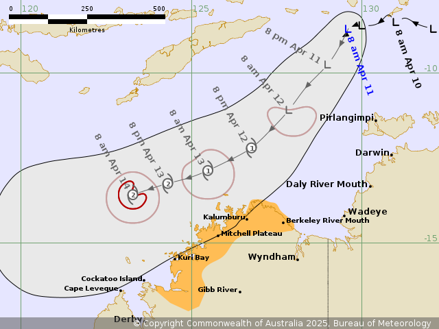
Details of Tropical Low 29U at 8:00 am AWST:
Intensity: Tropical Low, sustained winds near the centre of 55
kilometres per hour with wind gusts to 85 kilometres per
hour.
Location: within 55 kilometres of 8.7 degrees South 129.6 degrees
East, estimated to be 435 kilometres north northwest of Darwin and
315 kilometres north northwest of Pirlangimpi.
Movement: slow moving.
Tropical Low 29U is located to the north-northwest of Darwin, and
is forecast to move southwest, across the Timor Sea over the next
few days, while remaining off the western Top End coast.
29U is expected to develop into a tropical cyclone during Saturday
with increasing risk of coastal impacts for the Kimberley coast
from late Saturday.
Hazards:
Gales with DAMAGING WIND GUSTS will possible develop between Kuri
Bay and Berkeley River Mouth, during Saturday evening. Gales with
DAMAGING WIND GUSTS will possible also develop between Cockatoo
Island and Kuri Bay during Sunday morning.
HEAVY RAINFALL will possible develop between Kuri Bay and Berkeley
River Mouth, during Saturday evening. HEAVY RAINFALL will possibly
extend westward and persist between Cockatoo Island and Berkeley
River Mouth during Sunday.
As the system moves past the Kimberley coast tides between
Cockatoo Island and Berkeley River Mouth may rise above the normal
high tide mark, but the sea level should not exceed the highest
tide of the year.
Recommended Action:
DFES advises: Ensure you know what to do in a cyclone. For the
latest DFES community alerts and warnings visit
www.emergency.wa.gov.au or download the Emergency WA app.
Current
Tropical Cyclones
11/Apr/2025 12:53 AM


