
Source: Bureau of Meteorology
TROPICAL CYCLONE ADVICE NUMBER 30
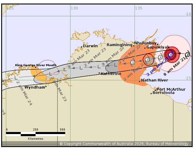
Issued at 4:18 pm ACST on Saturday 21 March 2026
Headline:
Severe Tropical Cyclone Narelle beginning to impact the eastern
Top End.
Areas Affected:
Warning Zone
Nhulunbuy to Nathan River, including Numbulwar, Alyangula, and
Gapuwiyak. Extending west to include Ramingining, Bulman, and
Ngukurr.
Watch Zone
King George River Mouth to the WA/NT Border.
Cancelled Zone
Port McArthur, including Borroloola.
Details of Severe Tropical Cyclone Narelle 34U at 3:30 pm
ACST:
Intensity: Category 3, sustained winds near the centre of 120
kilometres per hour with wind gusts to 165 kilometres per
hour.
Location: within 35 kilometres of 13.0 degrees South 137.8 degrees
East, estimated to be 140 kilometres southeast of Nhulunbuy and 175
kilometres east northeast of Alyangula.
Movement: west at 21 kilometres per hour.
Severe Tropical Cyclone Narelle is over the warm waters of the
Gulf of Carpentaria. Narelle is beginning to impact the eastern Top
End coast.
Narelle is forecast to cross the eastern Top End coast overnight
tonight or early Sunday morning, most likely between Birany Birany
and Numbulwar. Narelle will then weaken as it moves inland across
the Top End on Sunday and Monday.
During Monday, a weakened Narelle is expected to move over the
Joseph Bonaparte Gulf and gales are forecast to redevelop to the
north of the centre. There is a Moderate chance that Narelle
redevelops into a tropical cyclone while in the Joseph Bonaparte
Gulf.
Hazards:
VERY DESTRUCTIVE WINDS with gusts to 185 km/h are forecast to
develop in coastal areas between about Birany Birany and Numbulwar,
including Groote Eylandt, this evening and overnight into Sunday as
Narelle approaches from the east.
DESTRUCTIVE WIND GUSTS to 160 km/h are forecast to develop between
Birany Birany and Numbulwar, including Groote Eylandt from late
afternoon, and possibly extending to be between Nhulunbuy to Nathan
River overnight tonight or Sunday morning depending on the movement
of Narelle.
GALES with DAMAGING WIND GUSTS to 120 km/h developing in coastal
and adjacent inland areas between Gapuwiyak and Nathan River,
including Nhulunbuy, and are forecast to continue overnight into
Sunday. These GALES may extend west to Ramingining, Bulman, and
Ngukurr on Sunday.
HEAVY RAINFALL which may lead to FLASH FLOODING is developing
about coastal and adjacent inland areas over the eastern Top End
between Nhulunbuy and Nathan River, and is forecast to extend
further inland during Sunday. LOCALLY INTENSE RAINFALL leading to
DANGEROUS AND LIFE-THREATENING FLASH FLOODING is likely over the
eastern Top End between Birany Birany and Numbulwar, including
Groote Eylandt, during this afternoon and evening
Tides will be higher than normal between Nhulunbuy and Nathan
River today and Sunday. LARGE WAVES may produce MINOR FLOODING of
low-lying coastal areas. A potentially DANGEROUS STORM TIDE between
Cape Shield and Port Roper is possible as the cyclone centre
crosses the coast with DAMAGING WAVES and DANGEROUS FLOODING.
Western Australia:
GALES with DAMAGING WIND GUSTS to 90 km/h] are possible between
King George River Mouth and the WA/NT border.
HEAVY RAINFALL which may lead to FLASH FLOODING is possible for
the north Kimberley during Monday.
Recommended Action:
NTES advises:
People between Gapuwiyak and Numbulwar, including Groote Eylandt
and Nhulunbuy should remain inside until the cyclone has passed and
listen to the next advice.
People in remaining areas between Nhulunbuy and Nathan River,
including Borroloola, Numbulwar, Alyangula, and Gapuwiyak, should
immediately commence or continue preparations, especially securing
boats and property.
People further west including Ramingining, Bulman, and Ngukurr,
should take precautions and listen to the next advice.
- Outside property, including boats, playground equipment, chairs
and tables should be secured using available daylight hours.
- For cyclone preparedness and safety advice, visit the Secure NT
website at http://www.securent.nt.gov.au
- For emergency assistance call the Northern Territory Emergency
Service (NTES) on 132 500 (for assistance with storm damage, rising
flood water, fallen trees on buildings or roof damage).
DFES advises:
Ensure you know what to do in a cyclone. For the latest DFES
community alerts and warnings visit www.emergency.wa.gov.au or
download the Emergency WA app.
Current
Tropical Cyclones
21/Mar/2026 07:28 AM

