
Source: Bureau of Meteorology
TROPICAL CYCLONE ADVICE NUMBER 46
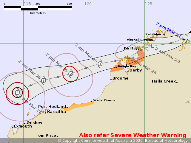
Issued at 2:53 pm WST on Monday 23 March 2026
Headline:
Ex-Tropical Cyclone Narelle moving across the north Kimberley
today and Tuesday, likely to redevelop over waters west of the
Kimberley early on Wednesday.
Areas Affected:
Warning Zone
Kuri Bay to Beagle Bay.
Watch Zone
Wallal Downs to Port Hedland.
Cancelled Zone
None.
Details of Ex-Tropical Cyclone Narelle 34U at 2:00 pm AWST:
Intensity: Tropical Low, sustained winds near the centre of 55
kilometres per hour with wind gusts to 85 kilometres per
hour.
Location: within 35 kilometres of 14.6 degrees South 128.2 degrees
East, estimated to be 105 kilometres north of Wyndham and 750
kilometres east northeast of Broome.
Movement: west southwest at 19 kilometres per hour.
Ex-Tropical Cyclone Narelle is currently crossing the northeast
Kimberley coast, north of Wyndham. It is expected to move west
southwest across the north Kimberley tonight and is not expected to
develop into a tropical cyclone during this period. However a
Severe Weather Warning is current for heavy rainfall and damaging
wind gusts for parts of the north Kimberley.
The system moves offshore from the northwest Kimberley coast
during Tuesday. Gales may develop to the north of the system and
impact exposed coastal areas of the northwest Kimberley coast west
of Kuri Bay, extending to Beagle Bay by Tuesday evening.
From Wednesday, the system will continue moving to the west
southwest, parallel to the Pilbara coast. There is a High chance of
redevelopment into a tropical cyclone by early Wednesday. While the
system is likely to remain offshore to the north, gales are
possible along the Pilbara coast from as early as Wednesday.
Longer term the system is expected to take a more southerly track
and may impact western parts of WA, however significant uncertainty
remains this.
Hazards:
HEAVY RAINFALL which may lead to FLASH FLOODING is likely to
develop across the north Kimberley during today and continue into
Tuesday morning.
GALES with DAMAGING WIND GUSTS to 90 km/h may develop along the
coast between Kuri Bay and Beagle Bay during Tuesday. Gales are
expected to ease by Wednesday morning, as the system move further
away from the west Kimberley coast.
GALES with DAMAGING WIND GUSTS to 100 km/h may develop along the
coast between Wallal Downs and Port Hedland from later Wednesday if
the system takes a track further south.
Recommended Action:
DFES advises:
Ensure you know what to do in a cyclone. For the latest DFES
community alerts and warnings visit www.emergency.wa.gov.au or
download the Emergency WA app.
Current
Tropical Cyclones
23/Mar/2026 06:58 AM

