
Source: Bureau of Meteorology
For people in parts of Gosford/Wyong and Sydney areas.
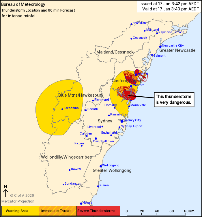
Issued at 3:42 pm Saturday, 17 January 2026.
INTENSE RAINFALL WITH THUNDERSTORMS NORTH OF SYDNEY AND SOUTHERN
CENTRAL COAST.
The Bureau of Meteorology warns that, at 3:40 pm, a VERY DANGEROUS
THUNDERSTORM likely to produce intense rainfall that may lead to
dangerous and life-threatening flash flooding was detected near Woy
Woy and Brooklyn. This thunderstorm is slow moving. It is forecast
to affect Calga, Mount White and Kariong by 4:40 pm.
Other severe thunderstorms likely to produce heavy rainfall that
may lead to flash flooding were detected near Wyong and Ourimbah.
They are forecast to affect Tuggerah, Tuggerah Lake and Gorokan by
4:10 pm and The Entrance, Toukley and Berkeley Vale by 4:40
pm.
82.5MM OF RAINFALL WAS RECORDED AT PEARL BEACH IN THE 1 HOUR TO
2:34 PM.
93.5MM OF RAINFALL WAS RECORDED AT ETTALONG IN THE 1 HOUR TO 2:22
PM.
57 mm of rainfall was recorded at Kilcare Heights in the 1 hour to
2:34 pm.
65 mm of rainfall was recorded at Bensville in the 1 hour to 2:34
pm.
65 mm of rainfall was recorded at Woy Woy in the 1 hour to 2:33
pm.
71 mm of rainfall was recorded at Koolewong in the 1 hour to 2:26
pm.
62.5mm of rainfall was recorded at Avalon in the 1 hour to 2:13
pm.
The State Emergency Service advises that people should:
* Keep clear of creeks and storm drains.
* Don't walk, ride your bike or drive through flood water.
* If you are trapped by flash flooding, seek refuge in the highest
available place and ring 000 if you need rescue.
* Stay indoors away from windows, and keep children and pets
indoors as well.
For emergency help in flood and storms, ring the SES on 132
500.
Stay updated on the Hazards Near Me NSW app or the ACT ESA website
(https://esa.act.gov.au).
17/Jan/2026 05:11 AM

