
Source: Bureau of Meteorology
For people in parts of Hunter, Metropolitan, Illawarra, South
Coast and Mid North Coast Forecast Districts.
Issued at 10:40 am Sunday, 15 September 2024.
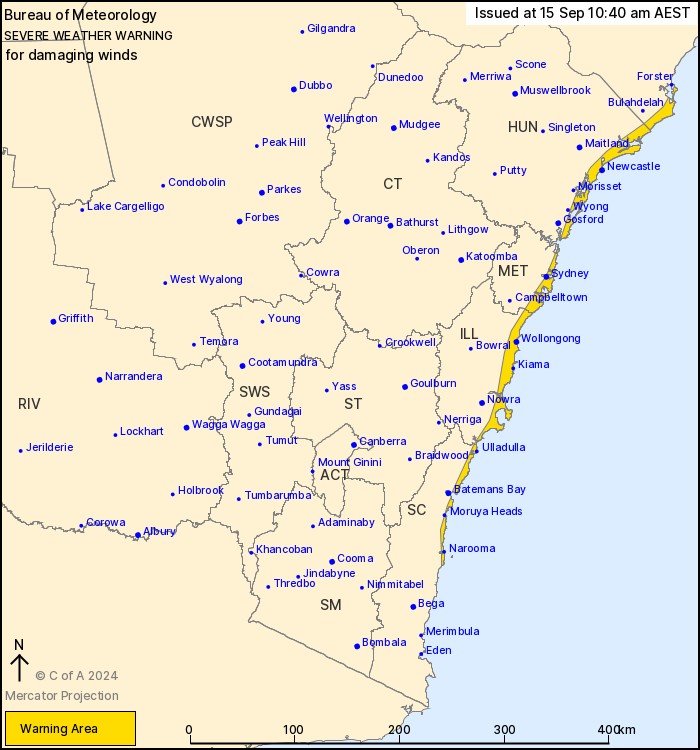
Damaging winds for coastal areas from near Narooma to south of
Forster today.
Weather Situation: A trough embedded within a robust south to
southwesterly airstream is extending northwards along the coast
today.
DAMAGING WINDS averaging 60 to 70 km/h with peak gusts of around
90 to 100 km/h are likely along coastal parts of the South Coast
and the Illawarra, extending to coastal parts of Sydney around
midday, and then Hunter and southern parts of the Mid North Coast
during the afternoon, especially with showers and
thunderstorms.
Winds are expected to weaken below warning thresholds from the
south and ease throughout by early evening.
A separate warning for DAMAGING SURF is current for parts of
Hunter, Metropolitan, Illawarra, South Coast and Mid North Coast
Forecast Districts.
Locations which may be affected include Newcastle, Sydney,
Wollongong, Moruya Heads, Ulladulla and Narooma.
Significant wind observations Sunday to 10:30 AEST include:
Sustained 69km/h winds were recorded at Wattamolla at 7:09am
91km/h wind gust was recorded at Wattamolla at 10:06am
The State Emergency Service advises that people should:
* Move vehicles under cover or away from trees.
* Secure or put away loose items around your house, yard and
balcony.
* Keep at least 8 metres away from fallen power lines or objects
that may be energised, such as fences.
* Trees that have been damaged by fire are likely to be more
unstable and more likely to fall.
* Report fallen power lines to either Ausgrid (131 388), Endeavour
Energy (131 003), Essential Energy (132 080) or Evoenergy (131 093)
as shown on your power bill.
* Stay vigilant and monitor conditions. Note that the landscape
may have changed following bushfires.
* For emergency help in floods and storms, ring your local SES
Unit on 132 500.
15/Sep/2024 01:00 AM


