
Source: Bureau of Meteorology
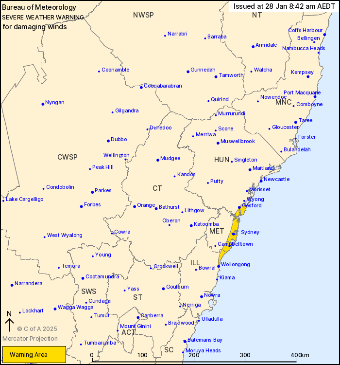
For people in parts of Metropolitan, Hunter and Illawarra Forecast
Districts.
Issued at 8:42 am Tuesday, 28 January 2025.
A southerly buster is likely to produce damaging winds along the
Sydney coast this afternoon.
Weather Situation: A vigorous southerly wind change will move
northwards along the south coast during the morning and is expected
to intensify about Wollongong and the Illawarra coast in the early
afternoon, before extending along the Sydney and Central Coast in
the late afternoon and early evening.
DAMAGING WINDS averaging 60 to 70 km/h with peak gusts in excess
of 90 km/h are likely along parts of the Illawarra, Sydney and
Hunter coasts, including the Sydney Enclosed waters, as the
southerly change moves through during the afternoon and early
evening.
Winds are expected to weaken below warning thresholds during the
evening.
Severe thunderstorms are also possible over parts of Greater
Sydney during the afternoon and early evening. A separate Severe
Thunderstorm Warning will be issued if this occurs.
Locations which may be affected include Gosford, Sydney,
Wollongong, The Entrance, Woy Woy and Bulli.
The State Emergency Service advises that people should:
* Move vehicles under cover or away from trees.
* Secure or put away loose items around your house, yard and
balcony.
* Keep at least 8 metres away from fallen power lines or objects
that may be energised, such as fences.
* Trees that have been damaged by fire are likely to be more
unstable and more likely to fall.
* Report fallen power lines to either Ausgrid (131 388), Endeavour
Energy (131 003), Essential Energy (132 080) or Evoenergy (131 093)
as shown on your power bill.
* Stay vigilant and monitor conditions. Note that the landscape
may have changed following bushfires.
* For emergency help in floods and storms, ring your local SES
Unit on 132 500.
27/Jan/2025 09:51 PM


