
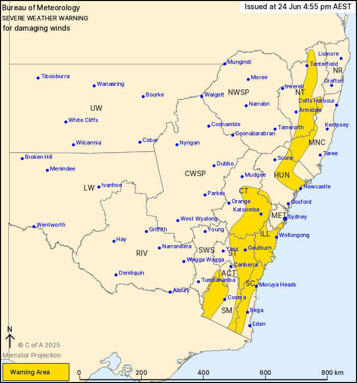
Source: Bureau of Meteorology
For people in Illawarra, South Coast, Southern Tablelands and
parts of Mid North Coast, Hunter, Metropolitan, Central Tablelands,
South West Slopes, Snowy Mountains, Australian Capital Territory
and Northern Tablelands Forecast Districts.
Issued at 4:55 pm Tuesday, 24 June 2025.
Damaging winds broadening about Great Dividing Range and southern
coast including Wollongong tonight, extending to southeastern
Sydney and Newcastle on Wednesday.
Weather Situation: A trough progressed across the state today,
with damaging winds persisting in its wake about southern elevated
parts. Westerly winds are expected to strengthen broadly tonight,
ahead of a strong cold front which will cross the state on
Wednesday, bringing a risk of damaging winds about the Great
Dividing Range and adjacent coastal parts of the South Coast,
Illawarra, southeastern Sydney and Hunter.
For ALPINE AREAS above 1900 metres: DAMAGING WINDS averaging 75 to
85 km/h with peak gusts up to 120 km/h possible tonight and early
Wednesday.
For ACT RANGES, SNOWY MOUNTAINS AND SOUTH COAST RANGES: DAMAGING
WINDS averaging 55 to 65 km/h with peak gusts of around 100 km/h
are possible tonight and Wednesday morning, reaching up to 120 km/h
about the South Coast Ranges. BLIZZARD conditions are also possible
over parts of the Snowy Mountains district above 1400 metres during
this time. The NSW National Parks and Wildlife Service recommends
that back country travel be postponed until conditions
improve.
For SOUTHEASTERN SYDNEY: Strong winds averaging 50 to 60 km/h with
DAMAGING WIND GUSTS around 90 km/h are possible from mid morning
Wednesday, easing below warning thresholds by Wednesday
evening.
For remaining SOUTHEASTERN AREAS including BLUE MOUNTAINS,
ILLAWARRA AND WOLLONGONG: DAMAGING WINDS averaging 55 to 65 km/h
with peak gusts around 100 km/h are possible from this evening,
easing below warning thresholds by Wednesday evening.
For NORTHEASTERN AREAS including THE HUNTER VALLEY AND NEWCASTLE:
DAMAGING WINDS averaging 55 to 65 km/h with peak gusts around 90
km/h are expected to develop mid Wednesday morning, contracting to
the ranges in the evening.
Locations which may be affected include Newcastle, Wollongong,
Goulburn, Nowra, Batemans Bay, Katoomba, Moruya Heads, Cessnock,
Maitland, Bowral, Braidwood and Bombala.
93 km/h wind gust was recorded at Cabramurra at 9:43 am.
Sustained winds above 90 km/h were observed at Thredbo Top Station
around 9:30 am.
The State Emergency Service advises that people should:
* Move vehicles under cover or away from trees.
* Secure or put away loose items around your house, yard and
balcony.
* Keep at least 8 metres away from fallen power lines or objects
that may be energised, such as fences.
* Trees that have been damaged by fire are likely to be more
unstable and more likely to fall.
* Report fallen power lines to either Ausgrid (131 388), Endeavour
Energy (131 003), Essential Energy (132 080) or Evoenergy (131 093)
as shown on your power bill.
* Stay vigilant and monitor conditions. Note that the landscape
may have changed following bushfires.
* For emergency help in floods and storms, ring your local SES
Unit on 132 500.
24/Jun/2025 07:01 AM

