
Source: Bureau of Meteorology
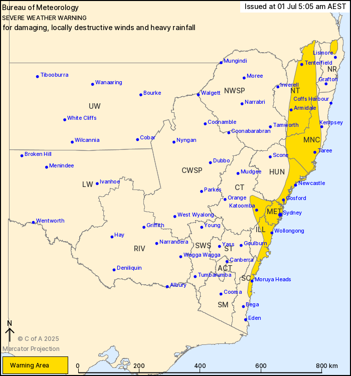
For people in Mid North Coast, Metropolitan, Northern Tablelands
and parts of Northern Rivers, Hunter, Illawarra, South Coast,
Central Tablelands and North West Slopes and Plains Forecast
Districts.
Issued at 5:05 am Tuesday, 1 July 2025.
VIGOROUS COASTAL LOW DEVELOPING OFFSHORE TO BRING DAMAGING,LOCALLY
DESTRUCTIVE WINDS AND POSSIBLE HEAVY RAINFALL OVER CENTRAL,
SOUTHERN AND NORTHERN NSW FROM TODAY.
Weather Situation: A rapidly deepening complex low pressure system
is forecast to develop a vigorous Coastal Low offshore of the Mid
North Coast early this morning, before it slowly tracks southwards
and approach the central NSW coast later today before turning and
moving offshore into the Tasman Sea on Wednesday. Winds are
forecast to strengthen along the coastal fringe from this morning,
extending to the northern ranges and their eastern lee slopes from
Tuesday evening, with a moist southeasterly airstream likely to
develop on the southern flank of the system, bringing possible
heavy rainfall to the central and southern coastlines.
For coastal parts of the HUNTER and MID NORTH COAST, including
NEWCASTLE: DAMAGING SOUTH TO SOUTHWESTERLY WINDS averaging 60 to 70
km/h with peak gusts of around 110 km/h are possible from early
this morning, becoming likely from the afternoon onwards. Locally
DESTRUCTIVE WIND GUSTS with peak gusts in excess of 125 km/h are
also possible from midday today for exposed coastal areas between
Newcastle and Forster. Isolated HEAVY RAINFALL which may lead to
FLASH FLOODING is also possible for the coastal fringe south of
Seal Rocks this morning. Six-hourly rainfall totals between 70 to
90 mm are possible, with isolated totals up to 120 mm.
For the SOUTHERN and CENTRAL COASTAL FRINGE, including SYDNEY,
WOLLONGONG and the CENTRAL COAST: DAMAGING SOUTH TO SOUTHWESTERLY
WINDS averaging 60 to 70 km/h with peak gusts of around 110 km/h
are likely to develop from Tuesday afternoon, extending to
Ulladulla by the evening.Locally DESTRUCTIVE WIND GUSTS with peak
gusts in excess of 125 km/h are also possible this afternoon for
exposed Sydney metro and northern Illawarra coastal areas between
about Bondi and Wollongong. Isolated HEAVY RAINFALL which may lead
to FLASH FLOODING is also possible for the coastal fringe north of
Ulladulla from this morning. Six-hourly rainfall totals between 70
to 90 mm are possible, with isolated totals up to 120 mm.
For the NORTHERN GREAT DIVIDING RANGE: Strong to DAMAGING WEST TO
SOUTHWESTERLY WINDS averaging 55 to 65 km/h with peak gusts of
around 90 km/h are likely to develop during Tuesday evening and
about the Scenic Rim close to Queensland border from early
Wednesday morning.
Subject to the position and strength of the Coastal Low, DAMAGING
WINDS and possible HEAVY RAINFALL are likely to persist into
Wednesday for parts of NSW.
A separate Coastal Hazard Warning is also current for parts of the
NSW coast. Refer to: http://www.bom.gov.au/nsw/warnings/
Locations which may be affected include Taree, Newcastle, Gosford,
Sydney, Wollongong, Armidale, Nowra and Batemans Bay.
The State Emergency Service advises that people should:
* Move vehicles under cover or away from trees.
* Secure or put away loose items around your house, yard and
balcony.
* Keep at least 8 metres away from fallen power lines or objects
that may be energised, such as fences.
* Trees that have been damaged by fire are likely to be more
unstable and more likely to fall.
* Report fallen power lines to either Ausgrid (131 388), Endeavour
Energy (131 003), Essential Energy (132 080) or Evoenergy (131 093)
as shown on your power bill.
* Don't drive, ride or walk through flood water.
* Keep clear of creeks and storm drains.
* If you are trapped by flash flooding, seek refuge in the highest
available place and ring 000 if you need rescue.
* Be aware that run-off from rainfall in fire affected areas may
behave differently and be more rapid. It may also contain debris
such as ash, soil, trees and rocks.
* After bushfires, heavy rain and the loss of foliage can make the
ground soft and heavy, leading to a greater chance of
landslides.
* Stay vigilant and monitor conditions. Note that the landscape
may have changed following bushfires.
* For emergency help in floods and storms, ring your local SES
Unit on 132 500.
30/Jun/2025 09:10 PM


