
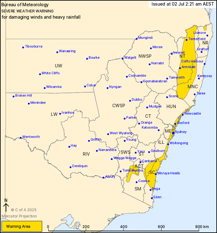
Source: Bureau of Meteorology
For people in parts of Mid North Coast, Hunter, Metropolitan,
Illawarra, South Coast, Southern Tablelands, Snowy Mountains,
Australian Capital Territory, Northern Tablelands, Northern Rivers
and South West Slopes Forecast Districts.
Issued at 2:21 am Wednesday, 2 July 2025.
Vigorous coastal low to bring damaging winds and heavy rainfall to
eastern NSW and southern ACT.
Weather Situation: A vigorous coastal low-pressure system is
currently located offshore to the east of Sydney, gradually
tracking northeastwards into the Tasman Sea during Wednesday,
bringing damaging winds and heavy rainfall along the coastline and
elevated parts of the state.
HEAVY RAINFALL which may lead to FLASH FLOODING continues in the
southeast, south of about Nowra. Six-hourly rainfall totals between
50 to 80 mm are likely, with isolated totals up to 120 mm. Rain
rates are forecast to ease during Wednesday morning.
DAMAGING SOUTH TO SOUTHWESTERLY WINDS averaging 60 to 70 km/h with
peak gusts of around 110 km/h are possible along coastal parts from
the South Coast to the Mid North Coast, including eastern Sydney
Metropolitan area. DAMAGING SOUTH TO SOUTHWESTERLY WIND GUSTS
around 90 km/h are possible for parts of the Snowy Mountains and
southern ACT.
Strong to DAMAGING WEST TO SOUTHWESTERLY WINDS averaging 55 to 65
km/h with peak gusts of around 100 km/h are likely to develop about
parts of the Northern Tablelands, the Mid North Coast hinterland
and about the Border Ranges from early Wednesday morning, and are
expected to continue through Wednesday.
Impacts associated with the complex low will likely be on an
easing trend during Thursday, but pulses of increased winds and
rainfall associated with this system could continue to impact areas
of eastern NSW.
A separate Coastal Hazard Warning is also current for parts of the
NSW coast. Refer to: http://www.bom.gov.au/nsw/warnings/
Locations which may be affected include Newcastle, Gosford,
Sydney, Wollongong, Armidale, Nowra, Batemans Bay, Tenterfield,
Katoomba, Moruya Heads and Penrith.
Significant rainfall observations:
80.5 mm was recorded at Oranmeir in the 6 hours to 2:05 am.
108 mm was recorded at Nowra in the 6 hours to 12:02 am.
133 mm was recorded at Morton in the 6 hours to 11:43 pm.
116 mm was recorded at Vincentia in the 6 hours to 9:37 pm.
121 mm was recorded at Greenwell Point in the 6 hours to 9:10
pm.
112 mm was recorded at Currarong in the 6 hours to 8:42 pm.
Significant wind observations:
100 km/h gust was recorded at Jervis Bay Airfield at 7:36
pm.
102 km/h gust was recorded at Point Perpendicular at 7:33
pm.
104 km/h gust was recorded at Ulladulla at 7:21 pm.
102 km/h gust was recorded at Penrith at 6:27 pm.
91 km/h gust was recorded at Wollongong at 6:21 pm.
91 km/h gust was recorded at Kiama at 4:04 pm.
The State Emergency Service advises that people should:
* Don't drive, ride or walk through flood water.
* Keep clear of creeks and storm drains.
* If you are trapped by flash flooding, seek refuge in the highest
available place and ring 000 if you need rescue.
* Be aware that run-off from rainfall in fire affected areas may
behave differently and be more rapid. It may also contain debris
such as ash, soil, trees and rocks.
* After bushfires, heavy rain and the loss of foliage can make the
ground soft and heavy, leading to a greater chance of
landslides.
* Move vehicles under cover or away from trees.
* Secure or put away loose items around your house, yard and
balcony.
* Keep at least 8 metres away from fallen power lines or objects
that may be energised, such as fences.
* Trees that have been damaged by fire are likely to be more
unstable and more likely to fall.
* Report fallen power lines to either Ausgrid (131 388), Endeavour
Energy (131 003), Essential Energy (132 080) or Evoenergy (131 093)
as shown on your power bill.
* Stay vigilant and monitor conditions. Note that the landscape
may have changed following bushfires.
* For emergency help in floods and storms, ring your local SES
Unit on 132 500.
01/Jul/2025 04:50 PM


