
Source: Bureau of Meteorology
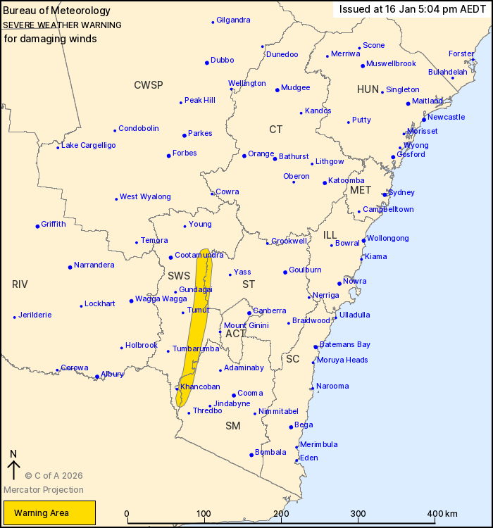
For people in parts of South West Slopes, Snowy Mountains and
Southern Tablelands Forecast Districts.
Issued at 5:04 pm Friday, 16 January 2026.
Severe risk easing near the coast, damaging easterly winds
possible inland tonight.
Weather Situation: A coastal trough is located offshore of the
Illawarra this afternoon, directing a fresh south to southeasterly
flow with showers onto the coast. While the immediate threat of
heavy rainfall and damaging winds near the coast has eased, there
is some chance during Saturday the trough will re-approach the
Illawarra and Sydney coasts with some renewed risks.
DAMAGING EAST TO SOUTHEASTERLY WINDS, averaging 50 to 60 km/h with
peak gusts of around 90 km/h are possible on the western slopes of
the Great Dividing Range from this evening.
Damaging winds are expected to ease below severe thresholds by
late Saturday morning.
In the event that heavy rainfall becomes a renewed threat near the
Illawarra or Sydney coasts during Saturday, a Severe Thunderstorm
Warning will be issued.
A separate severe weather warning for DAMAGING SURF is current.
For all the latest warnings, please check:
https://www.bom.gov.au/weather-and-climate/warnings-and-alerts.
Locations which may be affected include Cabramurra.
The State Emergency Service advises that people should:
* Park your car under secure cover and away from trees, powerlines
and drains.
* Secure or put away loose items around your house, yard and
balcony.
* Keep at least 8 metres away from fallen power lines or objects
that may be energised, such as fences.
* Report fallen power lines to either Ausgrid (131 388), Endeavour
Energy (131 003), Essential Energy (132 080) or Evoenergy (131 093)
as shown on your power bill.
For emergency help in flood and storms, ring the SES on 132
500.
Stay updated on the Hazards Near Me NSW app or the ACT ESA website
(https://esa.act.gov.au).
16/Jan/2026 06:09 AM

