
Source: Bureau of Meteorology
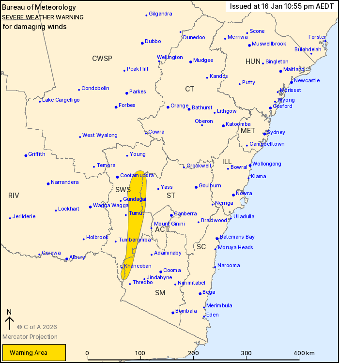
For people in parts of Southern Tablelands, South West Slopes and
Snowy Mountains Forecast Districts.
Issued at 10:55 pm Friday, 16 January 2026.
Damaging easterly winds occurring over the western slopes of the
divide tonight, continuing into Saturday.
Weather Situation: A coastal trough is located offshore of the
Illawarra tonight, directing strong easterly winds aloft over the
Great Dividing Range.
DAMAGING EAST TO SOUTHEASTERLY WINDS, averaging 60 to 70 km/h with
peak gusts of around 100 km/h are occurring on the western slopes
of the Great Dividing Range tonight, and are expected to continue
into Saturday. Damaging winds are expected to ease below severe
thresholds later on Saturday afternoon.
The coastal trough is also directing fresh south to southeasterly
flow over the Illawarra and Sydney Coasts tonight, and the
potential for localised heavy rainfall and damaging winds is being
closely monitored.
A separate severe weather warning for DAMAGING SURF is current.
For all the latest warnings, please check:
https://www.bom.gov.au/weather-and-climate/warnings-and-alerts.
Locations which may be affected include Cabramurra.
The State Emergency Service advises that people should:
* Park your car under secure cover and away from trees, powerlines
and drains.
* Secure or put away loose items around your house, yard and
balcony.
* Keep at least 8 metres away from fallen power lines or objects
that may be energised, such as fences.
* Report fallen power lines to either Ausgrid (131 388), Endeavour
Energy (131 003), Essential Energy (132 080) or Evoenergy (131 093)
as shown on your power bill.
For emergency help in flood and storms, ring the SES on 132
500.
Stay updated on the Hazards Near Me NSW app or the ACT ESA website
(https://esa.act.gov.au).
16/Jan/2026 12:23 PM

