
Source: Bureau of Meteorology
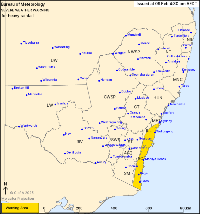
For people in Illawarra, South Coast and parts of Metropolitan and
Southern Tablelands Forecast Districts.
Issued at 4:30 pm Sunday, 9 February 2025.
Periods of heavy rain possible about coastal districts during
Monday and Tuesday.
Weather Situation: A developing upper low on Monday combined with
a very moist onshore flow will generate conditions favourable for
heavy rainfall along the southern and central coastal districts
during Monday and Tuesday.
Periods of HEAVY RAINFALL which may lead to FLASH FLOODING are
possible over parts of southern and central coastal districts from
Monday afternoon through the overnight period into Tuesday morning,
then becoming less likely later on Tuesday. Scattered six-hourly
rainfall totals between 40 and 80 mm are possible, with isolated
totals of 120 mm possible.
Isolated HEAVY RAINFALL is also possible with thunderstorms for
the remainder of Sunday and Monday morning, and will be covered by
separate Severe Thunderstorm Warnings as required.
Locations which may be affected include Wollongong, Nowra, Bowral,
Batemans Bay, Eden and Moruya Heads.
The State Emergency Service advises that people should:
* Don't drive, ride or walk through flood water.
* Keep clear of creeks and storm drains.
* If you are trapped by flash flooding, seek refuge in the highest
available place and ring 000 if you need rescue.
* Be aware that run-off from rainfall in fire affected areas may
behave differently and be more rapid. It may also contain debris
such as ash, soil, trees and rocks.
* After bushfires, heavy rain and the loss of foliage can make the
ground soft and heavy, leading to a greater chance of
landslides.
* Stay vigilant and monitor conditions. Note that the landscape
may have changed following bushfires.
* For emergency help in floods and storms, ring your local SES
Unit on 132 500.
09/Feb/2025 05:47 AM


