
Source: Bureau of Meteorology
For people in parts of Southeast Coast Forecast District.
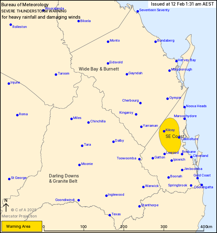
Issued at 1:31 am Wednesday, 12 February 2025.
INTENSE RAINFALL HAS EASED TO HEAVY FALLS TO THE NORTHWEST OF
BRISBANE.
Weather Situation: Severe thunderstorms are easing across the
southern interior of Queensland, but are continuing about the
southeast supported by an upper level trough and unstable
airmass.
Severe thunderstorms are likely to produce heavy rainfall that may
lead to flash flooding and damaging winds in the warning area over
the next several hours. Locations which may be affected include
Caboolture, Woodford, Kilcoy and Samford.
Severe thunderstorms are no longer occurring in the Wide Bay and
Burnett, Maranoa and Warrego and Darling Downs and Granite Belt
districts and the warning for these districts is CANCELLED.
79mm WAS RECORDED IN 55 MINS TO 12:13am AT LIMESTONE PARK
(IPSWICH)
55.0 mm WAS RECORDED IN 30 MINS TO 10:09 PM AT WARAHGAI.
53.0mm was recorded in 30 mins to 10:59 pm at Kalbar.
49.0 mm was recorded in 30 mins to 10:05 pm at Dieckmans
Bridge.
Emergency services advise people to:
* Park your car undercover away from trees.
* Close doors and windows.
* Keep asthma medications close by. Storms and wind can trigger
asthma attacks.
* Charge mobile phones and power banks in case the power goes
out.
* Put your pets somewhere safe and make sure they can be
identified in case they get lost.
* Do not drive now unless you have to because conditions are
dangerous.
* Tell friends, family and neighbours in the area.
* Go inside a strong building now. Stay inside until the storm has
passed.
11/Feb/2025 03:39 PM


