
Source: Bureau of Meteorology
Issued at 4:44 pm Monday, 27 January 2025.
Heavy rainfall expected to develop from tonight and throughout
Tuesday.
Weather Situation: A gradually deepening trough over the western
Coral Sea is likely to drift to the west onto the North Tropical
Coast overnight and during Tuesday. A strengthening ridge along the
central Queensland coast will assist in enhancing the very moist
onshore flow on the southern flank of the trough.
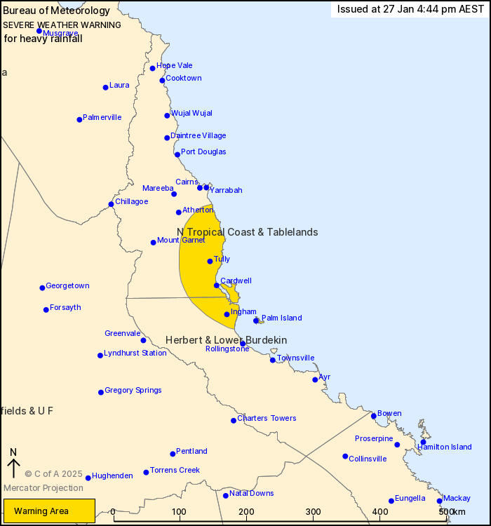
HEAVY RAINFALL which may lead to FLASH FLOODING is forecast to
develop from Babinda to Ingham from this evening and through
Tuesday. Six-hourly rainfall totals between 150 and 200 mm are
possible. 24-hour totals of 220 to 320 mm are also possible.
An Initial Flood Watch for parts of the north tropical coast is
also current here: http://www.bom.gov.au/cgi-bin/wrap
fwo.pl?IDQ20900.html
Locations which may be affected include Palm Island, Ingham,
Innisfail, Cardwell, Abergowrie and Lucinda.
Emergency services advise people to:
* Park your car undercover away from trees.
* Close doors and windows.
* Keep asthma medications close by. Storms and wind can trigger
asthma attacks.
* Charge mobile phones and power banks in case the power goes
out.
* Put your pets somewhere safe and make sure they can be
identified in case they get lost.
* Do not drive now unless you have to because conditions are
dangerous.
* Tell friends, family and neighbours in the area.
* Go inside a strong building now. Stay inside until the storm has
passed.
27/Jan/2025 06:51 AM


