
Source: Bureau of Meteorology
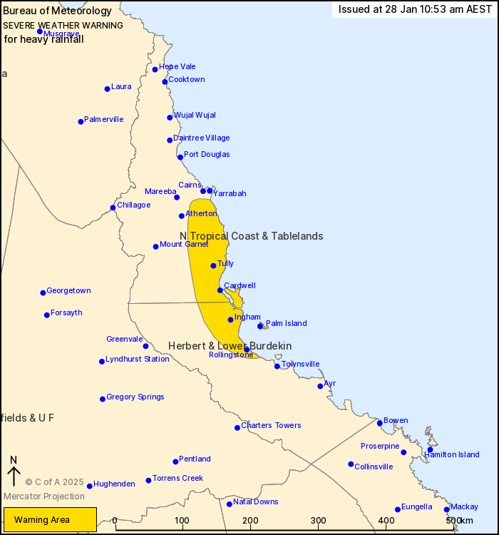
For people in parts of North Tropical Coast and Tablelands and
Herbert and Lower Burdekin Forecast Districts.
Issued at 10:53 am Tuesday, 28 January 2025.
Heavy rainfall is continuing along the North Tropical Coast
today.
Weather Situation: A surface low has developed north of Cairns,
with a trough deepening near the North Tropical Coast and combining
with a ridge of high pressure further south to push deep moisture
and rain areas onshore. The low and trough are forecast to shift
offshore during Wednesday morning.
HEAVY RAINFALL which may lead to FLASH FLOODING is forecast to
continue today over coastal communities and islands between about
Gordonvale and Rollingstone, and inland to the coastal side of the
Tablelands. Six-hourly rainfall totals between 130 and 180 mm are
possible. More isolated 24-hour totals of 200 to 300 mm are also
possible.
HEAVY RAINFALL is forecast to contract south of Innisfail
overnight before easing below warning thresholds by late Wednesday
morning.
Flood watches and flood warnings are also current for the region,
please refer to: http://www.bom.gov.au/qld/warnings/
Locations which may be affected include Palm Island, Ingham,
Innisfail, Cardwell, Abergowrie and Lucinda.
Emergency services advise people to:
* Park your car undercover away from trees.
* Close doors and windows.
* Keep asthma medications close by. Storms and wind can trigger
asthma attacks.
* Charge mobile phones and power banks in case the power goes
out.
* Put your pets somewhere safe and make sure they can be
identified in case they get lost.
* Do not drive now unless you have to because conditions are
dangerous.
* Tell friends, family and neighbours in the area.
* Go inside a strong building now. Stay inside until the storm has
passed.
28/Jan/2025 01:02 AM


