
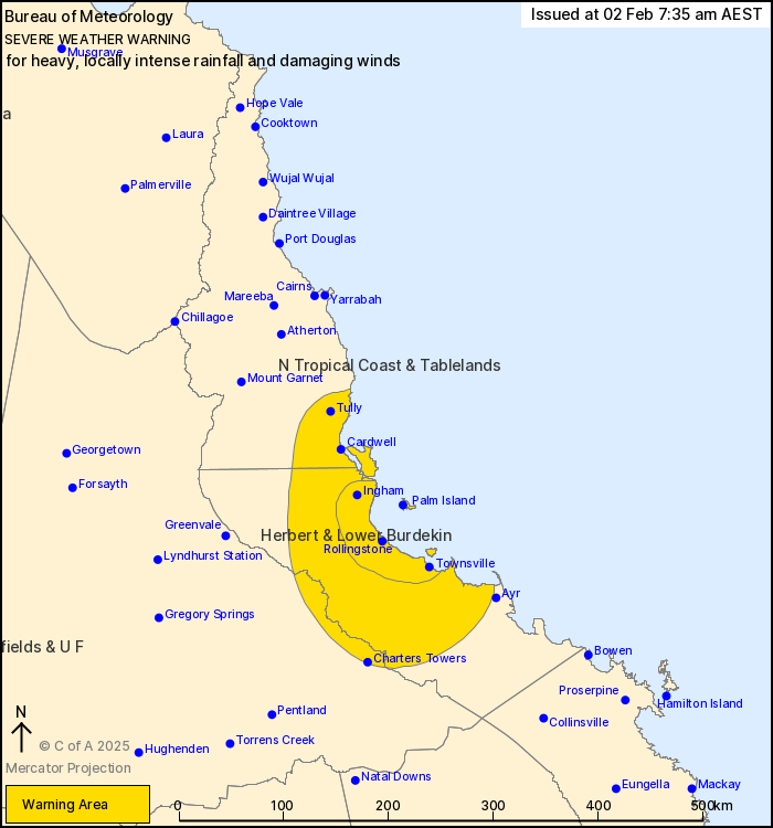
Source: Bureau of Meteorology
For people in parts of North Tropical Coast and Tablelands,
Northern Goldfields and Upper Flinders and Herbert and Lower
Burdekin Forecast Districts.
Issued at 7:35 am Sunday, 2 February 2025.
HEAVY RAINFALL LIKELY, WITH LOCALLY INTENSE FALLS POSSIBLE OVER
NORTHEAST QUEENSLAND.
Weather situation: An elongated low pressure system embedded
within the monsoon trough is currently located across the southern
Cape York Peninsula resulting in enhanced rainfall and winds about
the north east coasts of Queensland. Very significant rainfall
accumulations are expected due to the slow-moving nature of the low
and trough in an airmass rich in tropical moisture.
HEAVY RAINFALL which may lead to FLASH FLOODING is forecast
between Tully and Ayr, and inland to the far eastern Northern
Goldfields and Upper Flinders, including the towns of Charters
Towers, Ingham, Cardwell and Giru. Six-hourly rainfall totals
between 100 to 160 mm are likely, with isolated falls up to 200 mm.
24-hourly rainfall totals up to 300 mm are likely.
Locally INTENSE RAINFALL which may lead to DANGEROUS AND
LIFE-THREATENING FLASH FLOODING is also possible between Ingham and
Townsville during this period. Six-hourly rainfall totals between
160 to 250 mm are possible. 24-hourly totals up to 450 mm are
possible.
A separate Severe Thunderstorm Warning will be issued if very
dangerous thunderstorms with intense rainfall are detected.
Strong to DAMAGING WINDS averaging 55 to 65 km/h with peak gusts
of around 90 km/h are also possible for the islands and coastal
fringe between Tully and Giru.
The potential for heavy, locally intense rainfall and damaging
winds may continue into early next week subject to the strength and
position of the trough and low.
A Flood Watch and various Flood Warnings are current for parts of
northeastern Queensland. Please refer to
http://www.bom.gov.au/qld/warnings for more information.
Locations which may be affected include Charters Towers,
Townsville, Palm Island, Ingham, Cardwell, Giru, Woodstock,
Abergowrie and Lucinda.
Rainfall totals from 9 am to 7 am AEST:
699 mm recorded at Paluma Dam.
639 mm recorded at Rollingstone.
586 mm recorded at Pace Rd Rollingstone.
496 mm recorded at Paluma.
430 mm recorded at Wallaman Escarpment.
410 mm recorded at Upper Major Ck
409 mm recorded at Bluewater
381 mm recorded at Paradise Lagoon
372 mm recorded at Ingham Airport
Emergency services advise people to:
* If you have children make sure they are with you or an adult you
trust.
* Park your car undercover away from trees.
* Close doors and windows.
* Keep asthma medications close by. Storms and wind can trigger
asthma attacks.
* Charge mobile phones and power banks in case the power goes
out.
* Put your pets somewhere safe and make sure they can be
identified in case they get lost.
* Do not drive now unless you have to because conditions are
dangerous.
* Tell friends, family and neighbours in the area.
* Go inside a strong building now. Stay inside until the storm has
passed.
01/Feb/2025 10:03 PM


