
Source: Bureau of Meteorology
Issued at 7:54 am EST on Tuesday 12 December 2023
Headline:
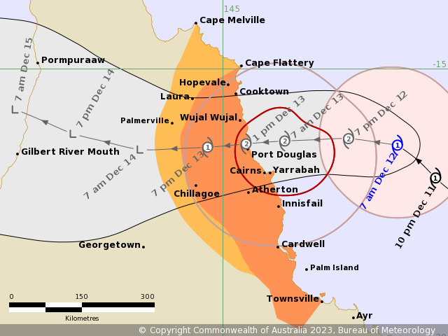
Tropical Cyclone Jasper, moving west northwestwards, is expected
to cross the Far North Queensland coast on Wednesday.
Areas Affected:
Warning Zone
Cape Flattery to Townsville (not including Townsville), including
Cairns, Innisfail and Palm Island, extending inland to include
Chillagoe
Watch Zone
Cape Melville to Cape Flattery, extending inland to include
Palmerville
Cancelled Zone
None.
Details of Tropical Cyclone Jasper at 7:00 am AEST:
Intensity: Category 1, sustained winds near the centre of 85
kilometres per hour with wind gusts to 120 kilometres per
hour.
Location: within 45 kilometres of 16.4 degrees South 148.2 degrees
East, estimated to be 265 kilometres east northeast of Cairns and
350 kilometres north northeast of Townsville.
Movement: northwest at 14 kilometres per hour.
Tropical Cyclone Jasper, currently a category 1 system, is
expected to re-intensify today as it moves west northwest towards
the coast. It is forecast to cross the coast as a category 2 system
on Wednesday, most likely between Cooktown and Innisfail. Jasper
will weaken as it moves inland during Thursday towards the Gulf of
Carpentaria. If the system is slower and crosses overnight
Wednesday or Thursday morning, a slim chance remains of a severe
category 3 crossing.
Hazards:
DESTRUCTIVE winds of up to 140 km/h are expected to develop
between Wujal Wujal and Innisfail, including Cairns from early
Wednesday morning.
GALES with DAMAGING WINDS of up to 120 km/h are expected to
develop along the Queensland coast and adjacent ranges between Cape
Flattery and Townsville, including Cairns, from this afternoon.
These DAMAGING WINDS are expected to extend inland to Palmerville
and Chillagoe after the cyclone has crossed the coast on
Wednesday.
GALES with DAMAGING WINDS may extend as far north as Cape Melville
on Wednesday, depending on the movement of Jasper.
HEAVY RAINFALL which may lead to FLASH FLOODING is forecast to
develop from early Wednesday morning between Cape Flattery and
Ingham. Six-hourly totals between 100 to 150 mm are likely, with
isolated falls of 250 mm possible along the coast and adjacent
ranges. 24-hourly rainfall totals between 150 to 250 mm are likely,
with isolated falls up to 350 mm possible.
A flood watch is current for the North Tropical Coast, parts of
the Cape York Peninsula and Gulf Country.
As the cyclone approaches the coast, a STORM TIDE is expected
between Cooktown and Townsville on the high tides today and
Wednesday. Large waves may produce minor flooding along the
foreshore. People living in areas likely to be affected by this
flooding should take measures to protect their property as much as
possible and be prepared to help their neighbours.
Recommended Action:
People between Cape Flattery and Townsville and adjacent parts
inland to Chillagoe should immediately commence or continue
preparations, especially securing boats and property.
- For cyclone preparedness and safety advice, visit Queensland's
Disaster Management Services website
(www.disaster.qld.gov.au)
- If you choose to take shelter away from your home, stay COVID-19
safe and pack a mask and hand sanitiser (if you have them).
- For emergency assistance call the Queensland State Emergency
Service (SES) on 132 500 (for assistance with storm damage, rising
flood water, fallen trees on buildings or roof damage).
People between Cape Melville and Cape Flattery, and inland to
Palmerville, should consider what action they will need to take if
the cyclone threat increases.
- Information is available from your local government.
- For cyclone preparedness and safety advice, visit Queensland's
Disaster Management Services website
(www.disaster.qld.gov.au).
- For emergency assistance call the Queensland State Emergency
Service (SES) on 132 500 (for assistance with storm damage, rising
flood water, fallen trees on buildings or roof damage).
Current
Tropical Cyclones
11/Dec/2023 10:14 PM


