
Source: Bureau of Meteorology
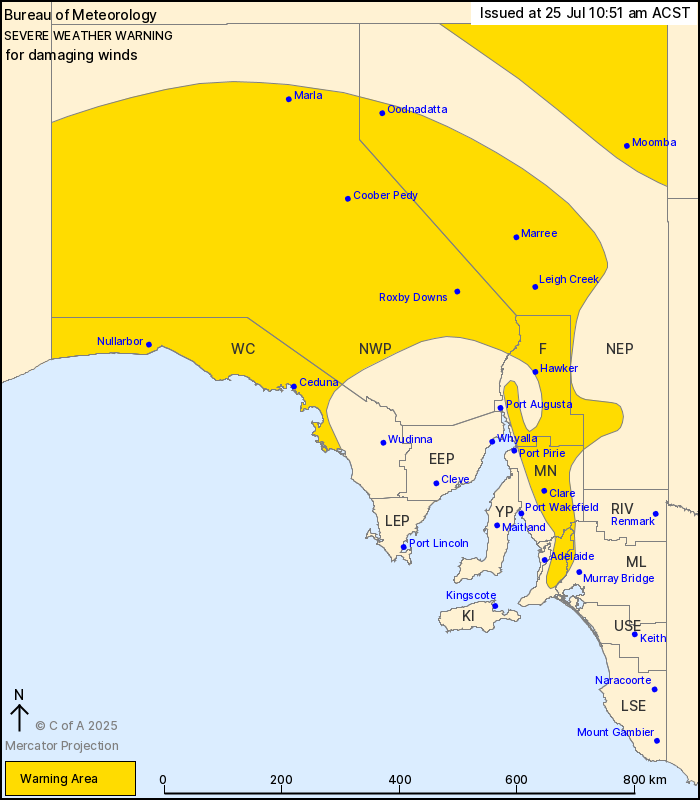
For people in West Coast, Flinders, Mid North, North West Pastoral
and parts of Mount Lofty Ranges, North East Pastoral and
Murraylands districts.
Issued at 10:51 am Friday, 25 July 2025.
A deep low pressure system in the Bight will bring windy
conditions across the state today.
Weather Situation: A deepening low pressure system in the Bight
extends a strong cold front about the west of the state. Strong and
gusty north to northeasterly winds are expected ahead of the front
as it tracks across the state during the day, with vigorous west to
southwesterly winds developing in its wake.
DAMAGING NORTH TO NORTHEASTERLY WINDS averaging 55 to 65 km/h with
peak gusts in excess of 90 km/h are expected about the Flinders and
Mount Lofty Ranges, and parts of the North East Pastoral during
today. Damaging winds are expected to shift westerly and contract
to the northern Flinders Ranges by late afternoon, and finally
below warning thresholds by early Saturday.
DAMAGING WEST TO SOUTHWESTERLY WINDS averaging 55 to 65 km/h with
peak gusts in excess of 90 km/h are expected in the west of the
state behind the front from late this morning, extending to central
parts in the afternoon. Winds are expected to ease below warning
thresholds inland early evening, and throughout by late
evening.
Locations which may be affected include Ceduna, Clare, Marla,
Coober Pedy, Roxby Downs and Leigh Creek.
Severe weather is no longer occurring in the Eastern Eyre
Peninsula district and the warning for this district is
CANCELLED.
93 km/h wind gust was recorded at Cleve Airport at 6:11 am.
The State Emergency Service advises that people should:
* Move vehicles under cover or away from trees;
* Secure or put away loose items around your property.
* Stay indoors, away from windows, while conditions are
severe.
25/Jul/2025 01:29 AM


