
Source: Bureau of Meteorology
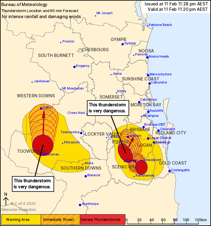
For people in parts of Ipswich, Logan, Scenic Rim, Western Downs,
Toowoomba, Brisbane City and Somerset Council Areas.
Issued at 11:50 pm Tuesday, 11 February 2025.
VERY DANGEROUS THUNDERSTORMS WITH INTENSE RAINFALL APPROACHING
IPSWICH AND DALBY.
The Bureau of Meteorology warns that, at 11:20 pm, VERY DANGEROUS
THUNDERSTORMS likely to produce heavy, locally intense rainfall
that may lead to dangerous and life-threatening flash flooding and
damaging winds were detected near Millmerran and Peak Crossing.
These thunderstorms are moving towards the north to northeast. They
are forecast to affect the area between Boonah and Beaudesert,
Cecil Plains and Tipton by 11:50 pm and Ipswich, Dalby and the area
east of Dalby by 12:20 am.
Another severe thunderstorm likely to produce heavy rainfall that
may lead to flash flooding and damaging winds was detected near
Beaudesert and Laravale. This thunderstorm is slow moving. It is
forecast to affect Kooralbyn by 11:50 pm.
55.0 mm WAS RECORDED IN 30 MINS TO 10:09 PM AT WARAHGAI
53.0 mm was recorded in 30 mins to 10:59 pm at Kalbar.
49.0 mm was recorded in 30 mins to 10:05 pm at Dieckmans
Bridge.
Emergency services advise people to:
* If you have children make sure they are with you or an adult you
trust.
* Park your car undercover away from trees.
* Close doors and windows.
* Keep asthma medications close by. Storms and wind can trigger
asthma attacks.
* Charge mobile phones and power banks in case the power goes
out.
* Put your pets somewhere safe and make sure they can be
identified in case they get lost.
* Do not drive now unless you have to because conditions are
dangerous.
* Tell friends, family and neighbours in the area.
* Go inside a strong building now. Stay inside until the storm has
passed.
11/Feb/2025 02:04 PM


