
Source: Bureau of Meteorology
For people in parts of Logan, Scenic Rim, Gold Coast and Redland
City Council Areas.
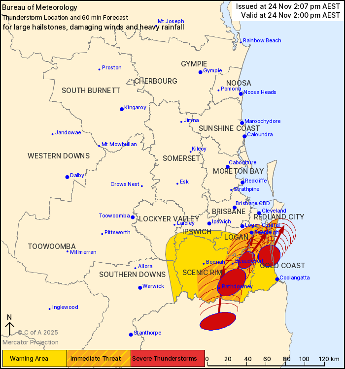
Issued at 2:07 pm Monday, 24 November 2025.
Severe thunderstorms continuing in the southeast
The Bureau of Meteorology warns that, at 2:00 pm, severe
thunderstorms likely to produce large hailstones, damaging winds
and heavy rainfall that may lead to flash flooding were detected
near Rathdowney, Laravale, Mount Tamborine, the area south of the
NSW border and South Stradbroke Island. These thunderstorms are
moving towards the north to northeast. They are forecast to affect
Beaudesert, Border Ranges National Park and Tamborine by 2:30 pm
and Beenleigh, Mount Barney and Maroon Dam by 3:00 pm.
Emergency services advise people to:
* Park your car undercover away from trees.
* Close doors and windows.
* Keep asthma medications close by. Storms and wind can trigger
asthma attacks.
* Charge mobile phones and power banks in case the power goes
out.
* Put your pets somewhere safe and make sure they can be
identified in case they get lost.
* Do not drive now unless you have to because conditions are
dangerous.
* Tell friends, family and neighbours in the area.
* Go inside a strong building now. Stay inside until the storm has
passed.
24/Nov/2025 04:15 AM

