
Source: Bureau of Meteorology
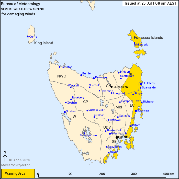
For people in Furneaux Islands and parts of South East, North
East, East Coast and Central North Forecast Districts.
Issued at 1:08 pm Friday, 25 July 2025.
Damaging winds expected in eastern and southeastern areas during
Saturday
Weather Situation: A deep low pressure system to the northwest of
the state will extend a cold front over northwestern parts
initially on Saturday morning. As the front tracks to the southeast
through the state, northeasterly winds strengthen and become
damaging, initially in the northeast by sunrise before shifting
down the east coast throughout the morning. The front clears the
southeast coast during Saturday afternoon with winds easing in its
wake.
Strong northeasterly winds averaging 45 to 55 km/h with DAMAGING
GUSTS around 90 km/h are expected to develop initially about the
Furneaux Islands and the northeast district before sunrise on
Saturday morning. Damaging winds will extend down the east coast to
include Tasman and Bruny Island by around midday.
Winds will ease north of Swansea in the late morning, before
clearing the state entirely by the late afternoon.
Locations which may be affected include St Helens, Swansea, Ben
Lomond, Whitemark, Bicheno, Orford and Fingal.
The State Emergency Service advises that people should:
* Supervise children closely.
* Check that family and neighbours are aware of warnings.
* Manage pets and livestock.
* Secure outdoor items including furniture and play
equipment.
* Be prepared in case of power outages and report any outages to
TasNetworks on 132 004.
* Beware of damaged trees and power lines and take care when
driving.
* Listen to the ABC radio or check www.ses.tas.gov.au for further
advice.
* For emergency assistance contact the SES on 132500.
25/Jul/2025 03:15 AM

