
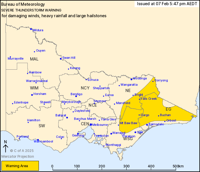
Source: Bureau of Meteorology
For people in East Gippsland and parts of North East and West and
South Gippsland Forecast Districts.
Issued at 5:47 pm Friday, 7 February 2025.
Isolated severe thunderstorms continuing in Eastern Victoria
Weather Situation: a surface trough moving through Eastern
Victoria in a humid and unstable airmass is producing severe
thunderstorms this evening. Thunderstorm activity is slowly
contracting further east.
Severe thunderstorms are likely to produce damaging winds, heavy
rainfall that may lead to flash flooding and large hailstones in
the warning area over the next several hours. Locations which may
be affected include Corryong, Maffra, Mallacoota, Falls Creek, Mt
Hotham and Omeo.
35mm was recorded at Greta South in the 30 minutes to 3:47pm
107 km/h wind gust was recorded at Wangaratta Airport at
3:25pm
The State Emergency Service advises that people should:
* If driving conditions are dangerous, safely pull over away from
trees, drains, low-lying areas and floodwater. Avoid travel if
possible.
* Stay safe by avoiding dangerous hazards, such as floodwater,
mud, debris, damaged roads and fallen trees.
* Be aware - heat, fire or recent storms may make trees unstable
and more likely to fall when it's windy or wet.
* Check that loose items, such as outdoor settings, umbrellas and
trampolines are safely secured. Move vehicles under cover or away
from trees.
* Stay indoors and away from windows.
* If outdoors, move to a safe place indoors. Stay away from trees,
drains, gutters, creeks and waterways.
* Stay away from fallen powerlines - always assume they are
live.
* Be aware that in fire affected areas, rainfall run-off into
waterways may contain debris such as ash, soil, trees and rocks.
Heavy rainfall may also increase the potential for landslides and
debris across roads.
* Stay informed: Monitor weather warnings, forecasts and river
levels at the Bureau of Meteorology website, and warnings through
VicEmergency website/app/hotline.
07/Feb/2025 06:58 AM


