
Source: Bureau of Meteorology
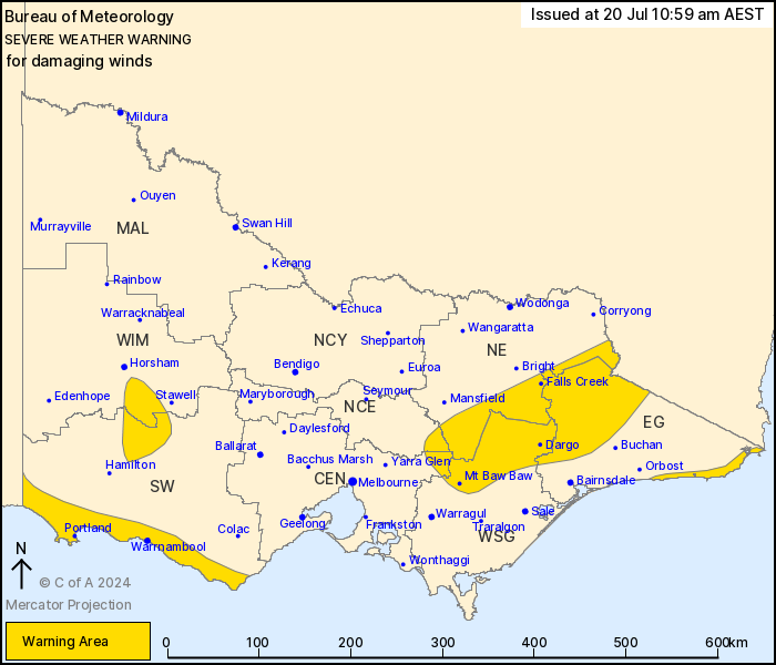
For people in parts of East Gippsland, South West, North Central,
North East, West and South Gippsland, Central and Wimmera Forecast
Districts.
Issued at 10:59 am Saturday, 20 July 2024.
Damaging winds about the alpine areas, Grampians, and South West
and East Gippsland coasts, with blizzard conditions about alpine
areas.
Weather Situation: A strong west to northwesterly flow ahead of a
cold front is causing damaging winds about the Grampians and
northeast ranges, with blizzard conditions about the alpine areas.
Winds are shifting southwesterly following the cold front along the
South West Coast district and expected to shift west to
southwesterly throughout during the afternoon. Winds easing from
the west during the late afternoon but persisting about the alpine
areas and East Gippsland Coast during the evening.
For the ALPINE AREAS: DAMAGING WINDS averaging 60 to 70 km/h with
peak gusts of around 100 km/h, along with BLIZZARD conditions above
1200 m are expected, easing during the evening.
For the GRAMPIANS: DAMAGING WINDS averaging 60 to 70 km/h with
peak gusts of around 100 km/h are expected, easing late
afternoon.
For the SOUTH WEST COAST: Strong southwesterly winds averaging 60
to 70 km/h with DAMAGING WIND GUSTS up to 100 km/h are expected,
easing late afternoon.
For the EAST GIPPSLAND COAST: Strong west to southwesterly winds
averaging 50 to 60 km/h with DAMAGING WIND GUSTS up to 100 km/h are
expected to develop during the late afternoon and continue into the
evening, before easing during Sunday morning.
Locations which may be affected include Warrnambool, Portland,
Falls Creek, Mt Hotham, Mt Buller and Omeo.
Significant wind observations to 10:00 am Saturday include:
119 km/h wind gust recorded at Mount William at 7:46 pm
Friday.
98 km/h wind gust recorded at Falls Creek at 9:58 pm Friday.
94 km/h wind gust recorded at Kilmore Gap at 11:30 pm
Friday.
102 km/h wind gust recorded at Mount Buller at 2:01 am
Saturday.
91 km/h wind gust recorded at Cape Nelson at 8:15 am
Saturday
The State Emergency Service advises that people should:
* If driving conditions are dangerous, safely pull over away from
trees, drains, low-lying areas and floodwater. Avoid travel if
possible.
* Stay safe by avoiding dangerous hazards, such as floodwater,
mud, debris, damaged roads and fallen trees.
* Be aware - heat, fire or recent storms may make trees unstable
and more likely to fall when it's windy or wet.
* Check that loose items, such as outdoor settings, umbrellas and
trampolines are safely secured. Move vehicles under cover or away
from trees.
* Stay indoors and away from windows.
* If outdoors, move to a safe place indoors. Stay away from trees,
drains, gutters, creeks and waterways.
* Stay away from fallen powerlines - always assume they are
live.
* Be aware that in fire affected areas, rainfall run-off into
waterways may contain debris such as ash, soil, trees and rocks.
Heavy rainfall may also increase the potential for landslides and
debris across roads.
* Stay informed: Monitor weather warnings, forecasts and river
levels at the Bureau of Meteorology website, and warnings through
VicEmergency website/app/hotline.
20/Jul/2024 01:12 AM

