
Source: Bureau of Meteorology
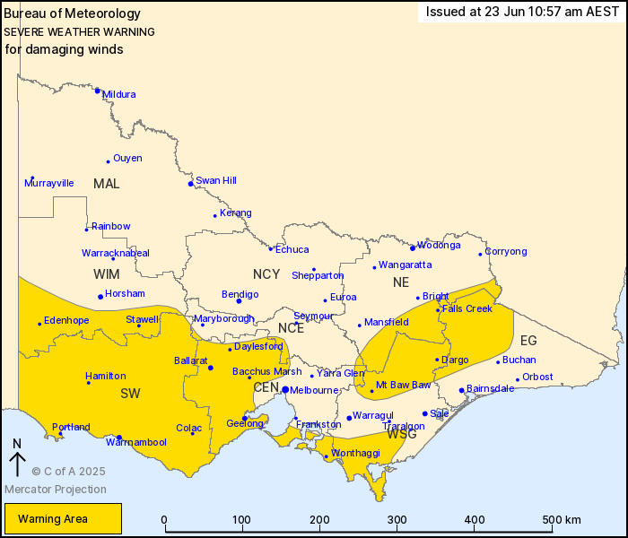
For people in South West and parts of Central, East Gippsland,
North Central, North East, West and South Gippsland and Wimmera
Forecast Districts.
Issued at 10:57 am Monday, 23 June 2025.
Damaging wind gusts occurring over alpine areas today, becoming
more widespread on Tuesday.
Weather Situation: A complex low pressure system in the Great
Australian Bight is extending a trough over central Victoria,
producing a strengthening northwesterly flow ahead of it about
alpine areas in the northeast. A second cold front will then
approach western Victoria on Tuesday and the pressure gradient will
continue to strengthen, leading to vigorous northwesterly flow with
damaging wind gusts becoming more widespread over western, central,
and northeastern parts of the state.
For NORTHEASTERN RANGES: Strong northwesterly winds averaging 50
to 60 km/h with DAMAGING WIND GUSTS of around 100 km/h are
occurring over alpine areas above 1400 metres this morning,
remaining possible for the rest of today. From Tuesday afternoon
ahead of the next cold front DAMAGING WIND GUSTS are likely to
become more widespread. Higher terrain above 1400 metres may then
experience DAMAGING WINDS averaging 60 to 70 km/h with peak gusts
of around 110 km/h, and BLIZZARD conditions are forecast to develop
here from Tuesday evening.
For WESTERN VICTORIA, CENTRAL VICTORIA AND GIPPSLAND: Strong winds
averaging 50 to 60 km/h with DAMAGING WIND GUSTS of around 90 km/h
are possible in showers and thunderstorms from midday Tuesday in
the Wimmera and South West districts, extending to central
districts during the afternoon, and west Gippsland by the
evening.
Locations which may be affected include Warrnambool, Ballarat,
Geelong, Stawell, Hamilton, Portland, Wonthaggi, Bacchus Marsh,
Daylesford, Falls Creek, Edenhope and Colac.
Sustained 69 km/h winds were recorded at Mount Hotham around 7:30
am, with a 104 km/h wind gust at 6:23 am.
107 km/h wind gust was recorded at Mount William at 2:13 am.
The State Emergency Service advises that people should:
* If driving conditions are dangerous, safely pull over away from
trees, drains, low-lying areas and floodwater. Avoid travel if
possible.
* Stay safe by avoiding dangerous hazards, such as floodwater,
mud, debris, damaged roads and fallen trees.
* Be aware - heat, fire or recent storms may make trees unstable
and more likely to fall when it's windy or wet.
* Check that loose items, such as outdoor settings, umbrellas and
trampolines are safely secured. Move vehicles under cover or away
from trees.
* Stay indoors and away from windows.
* If outdoors, move to a safe place indoors. Stay away from trees,
drains, gutters, creeks and waterways.
* Stay away from fallen powerlines - always assume they are
live.
* Be aware that in fire affected areas, rainfall run-off into
waterways may contain debris such as ash, soil, trees and rocks.
Heavy rainfall may also increase the potential for landslides and
debris across roads.
* Stay informed: Monitor weather warnings, forecasts and river
levels at the Bureau of Meteorology website, and warnings through
VicEmergency website/app/hotline.
23/Jun/2025 01:06 AM


