
Source: Bureau of Meteorology
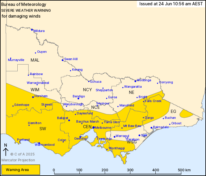
For people in Central, South West and parts of East Gippsland,
North Central, North East, West and South Gippsland and Wimmera
Forecast Districts.
Issued at 10:56 am Tuesday, 24 June 2025.
Damaging wind gusts becoming more widespread today.
Weather Situation: A complex low pressure system in the Bight will
extend a cold front over Victoria this afternoon. Vigorous
northwesterly winds are developing ahead of this front, with alpine
areas affected this morning followed by western and central parts
of the state this afternoon and evening.
For NORTHEASTERN RANGES and EAST GIPPSLAND: DAMAGING NORTHWESTERLY
WINDS averaging 65 to 75 km/h with peak gusts of around 120 km/h
are occurring and remain possible today over alpine areas above
1400 metres, with BLIZZARD conditions forecast to develop from this
evening. DAMAGING WIND GUSTS are likely to become more widespread
from this afternoon, including areas below 1400 metres.
Damaging winds are then forecast to ease below warning thresholds
during Wednesday morning.
For the WIMMERA, SOUTH WEST, CENTRAL and WEST GIPPSLAND: Strong
west to northwesterly winds averaging 50 to 60 km/h with DAMAGING
WIND GUSTS of around 90 km/h are possible from midday today for
coastal and elevated parts of the Wimmera and South West districts,
extending to the Central district during the afternoon, and western
Gippsland by this evening. DAMAGING WIND GUSTS are also possible in
showers and thunderstorms for inland and lower-lying parts of the
warning area throughout this afternoon.
Damaging winds are then forecast to ease below warning thresholds
in the west from early this evening, and over central areas and
west Gippsland later tonight.
A separate warning for ABNORMALLY HIGH TIDES is current for the
entire Victorian coast. Please refer to
http://www.bom.gov.au/warnings/
Locations which may be affected include Horsham, Warrnambool,
Ballarat, Geelong, Melbourne, Stawell, Hamilton, Portland and
Wonthaggi.
Sustained 74 km/h winds were recorded at Mount Hotham around 9:00
am with a 120 km/h wind gust at 9:05 am.
92 km/h wind gust was recorded at Mount Hotham Airport at 8:41
am.
Sustained 70 km/h winds were recorded at Mount Buller around 8:30
am with a 113 km/h wind gust at 8:36 am.
Sustained 65 km/h winds were recorded at Falls Creek Airport
around 12:50 am with a 101 km/h wind gust at 12:38 am.
The State Emergency Service advises that people should:
* If driving conditions are dangerous, safely pull over away from
trees, drains, low-lying areas and floodwater. Avoid travel if
possible.
* Stay safe by avoiding dangerous hazards, such as floodwater,
mud, debris, damaged roads and fallen trees.
* Be aware - heat, fire or recent storms may make trees unstable
and more likely to fall when it's windy or wet.
* Check that loose items, such as outdoor settings, umbrellas and
trampolines are safely secured. Move vehicles under cover or away
from trees.
* Stay indoors and away from windows.
* If outdoors, move to a safe place indoors. Stay away from trees,
drains, gutters, creeks and waterways.
* Stay away from fallen powerlines - always assume they are
live.
* Be aware that in fire affected areas, rainfall run-off into
waterways may contain debris such as ash, soil, trees and rocks.
Heavy rainfall may also increase the potential for landslides and
debris across roads.
* Stay informed: Monitor weather warnings, forecasts and river
levels at the Bureau of Meteorology website, and warnings through
VicEmergency website/app/hotline.
24/Jun/2025 01:03 AM


