
Source: Bureau of Meteorology
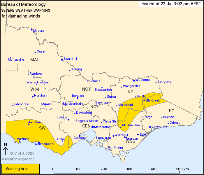
For people in parts of East Gippsland, South West, North East,
West and South Gippsland, Central and North Central Forecast
Districts.
Issued at 3:02 pm Tuesday, 22 July 2025.
Damaging winds continuing about the northeast ranges and southwest
until later this evening.
Weather Situation: A strong cold front is currently passing
through Eastern Victoria, and is forecast to move into NSW later
this evening. A deep low pressure system associated with this cold
front is located south of the SA border and will continue to move
through Bass Strait this evening.
For the EASTERN RANGES above 1600m: DAMAGING NORTHWESTERLY WINDS
averaging 70 to 85 km/h with peak gusts of around 115 km/h are
occurring this afternoon, with winds expected ease later in the
afternoon or early evening to average 55 to 70 km/h with peaks
gusts of around 100 km/hr. Winds are then expected to ease below
warnings thresholds later this evening. BLIZZARD conditions also
remain possible until later this evening.
For the SOUTHWEST, OTWAY RANGES and SURF COAST: Northwesterly
winds with DAMAGING WIND GUSTS peaking around 90 km/h are possible
this afternoon, contracting to coastal areas this evening before
finally easing throughout the warning area later this
evening.
Locations which may be affected include Warrnambool, Hamilton,
Portland, Falls Creek, Mt Baw Baw and Rosebud.
Severe weather is no longer occurring in the Northern Country and
Wimmera districts and the warning for these districts is
CANCELLED.
A 150 KM/H WIND GUST WAS RECORDED AT MOUNT HOTHAM AT 08:45
AM.
A 126 KM/H WIND GUST WAS RECORDED AT MOUNT WILLIAM AT 03:55
AM.
A 91 km/h wind gust was recorded at Hamilton Airport at
2:40pm.
A 91 km/h wind gust was recorded at Ballarat at 09:51 am.
A 95 km/h wind gust was recorded at Kilmore Gap at 07:56 am.
A 122 km/h wind gust was recorded at Mount Buller at 06:05
am.
A 119 km/h wind gust was recorded at Falls Creek Airport at 01:18
am.
The State Emergency Service advises that people should:
* If driving conditions are dangerous, safely pull over away from
trees, drains, low-lying areas and floodwater. Avoid travel if
possible.
* Stay safe by avoiding dangerous hazards, such as floodwater,
mud, debris, damaged roads and fallen trees.
* Be aware - heat, fire or recent storms may make trees unstable
and more likely to fall when it's windy or wet.
* Check that loose items, such as outdoor settings, umbrellas and
trampolines are safely secured. Move vehicles under cover or away
from trees.
* Stay indoors and away from windows.
* If outdoors, move to a safe place indoors. Stay away from trees,
drains, gutters, creeks and waterways.
* Stay away from fallen powerlines - always assume they are
live.
* Be aware that in fire affected areas, rainfall run-off into
waterways may contain debris such as ash, soil, trees and rocks.
Heavy rainfall may also increase the potential for landslides and
debris across roads.
* Stay informed: Monitor weather warnings, forecasts and river
levels at the Bureau of Meteorology website, and warnings through
VicEmergency website/app/hotline.
22/Jul/2025 05:08 AM

