
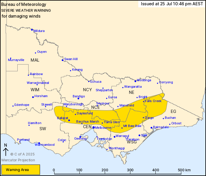
Source: Bureau of Meteorology
For people in parts of Central, East Gippsland, South West, North
Central, North East and West and South Gippsland Forecast
Districts.
Issued at 10:46 pm Friday, 25 July 2025.
DAMAGING WINDS EXPECTED TONIGHT AND TOMORROW WITH LOCALLY
DESTRUCTIVE WIND GUSTS AND BLIZZARD CONDITIONS FOR ALPINE
AREAS.
Weather Situation: A strong northerly flow ahead of an approaching
cold front is producing damaging winds over parts of the Great
Dividing Range and southern slopes. The front will move into
central and eastern parts of the state during early Saturday
morning before clearing to the east by the middle of the day.
For the CENTRAL RANGES, PYRENEES and northern suburbs of
MELBOURNE: DAMAGING NORTHERLY WINDS averaging 55 to 65 km/h with
peak gusts of around 110 km/h are possible for the remainder of
today and into early Saturday morning.
For the EASTERN RANGES above 1400m: DAMAGING, LOCALLY DESTRUCTIVE
WINDS averaging 70 to 90 km/h with peak gusts up to around 140 km/h
are likely this evening, easing to DAMAGING WINDS averaging 60 to
70 km/h with gusts of around 100 km/h on Saturday morning. Blizzard
conditions are also possible for alpine areas from late this
evening.
Winds are expected to ease below warning thresholds in central
areas by around sunrise, and over the Eastern Ranges by Saturday
afternoon.
Locations which may be affected include Ballarat, Bacchus Marsh,
Daylesford, Falls Creek, Yarra Glen and Dargo.
Significant wind gust observations to 10:45 pm:
146 KM/H AT MOUNT HOTHAM AT 10:02 PM.
131 KM/H AT MOUNT BULLER AT 9:30 PM.
91 km/h at Melbourne Airport at 10:36 pm
120 km/h at Kilmore Gap at 10:12 pm
107 km/h at Ben Nevis at 4:17 pm.
107 km/h wind at Mount William at 5:54 pm.
The State Emergency Service advises that people should:
* If driving conditions are dangerous, safely pull over away from
trees, drains, low-lying areas and floodwater. Avoid travel if
possible.
* Stay safe by avoiding dangerous hazards, such as floodwater,
mud, debris, damaged roads and fallen trees.
* Be aware - heat, fire or recent storms may make trees unstable
and more likely to fall when it's windy or wet.
* Check that loose items, such as outdoor settings, umbrellas and
trampolines are safely secured. Move vehicles under cover or away
from trees.
* Stay indoors and away from windows.
* If outdoors, move to a safe place indoors. Stay away from trees,
drains, gutters, creeks and waterways.
* Stay away from fallen powerlines - always assume they are
live.
* Be aware that in fire affected areas, rainfall run-off into
waterways may contain debris such as ash, soil, trees and rocks.
Heavy rainfall may also increase the potential for landslides and
debris across roads.
* Stay informed: Monitor weather warnings, forecasts and river
levels at the Bureau of Meteorology website, and warnings through
VicEmergency website/app/hotline.
25/Jul/2025 01:18 PM


