
Source: Bureau of Meteorology
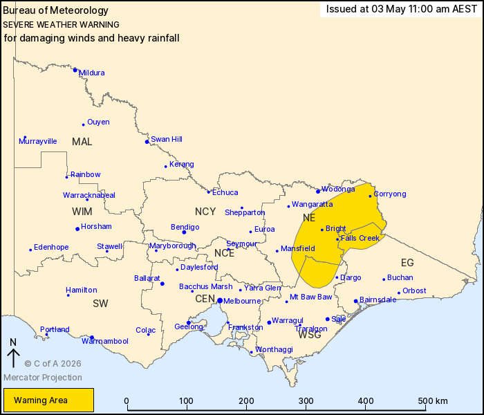
For people in parts of East Gippsland, North East and West and
South Gippsland Forecast Districts.
Issued at 11:00 am Sunday, 3 May 2026.
Damaging winds and heavy rainfall expected across elevated areas
of eastern Victoria Sunday.
Weather Situation: A cold front and associated upper-level
disturbance will traverse Victoria during Sunday, generating gusty
northerly winds ahead of the system during the afternoon and
evening. A cloud band continues to develop over eastern Victoria
during the afternoon and evening with rich atmospheric moisture and
embedded thunderstorms leading to the risk of heavy rainfall over
northeastern Victoria.
DAMAGING WINDS averaging 65 to 75 km/h with peak gusts of 110 km/h
are possible over elevated areas above 1600 metres during Sunday,
easing below warning thresholds by early Sunday evening. DAMAGING
WIND GUSTS up to 90 km/h are also possible with thunderstorms
within the warning area this afternoon and evening.
HEAVY RAINFALL which may lead to FLASH FLOODING is forecast for
parts of the eastern Victorian ranges from early Sunday evening,
particularly about the northern aspects. Six-hourly rainfall totals
up to 70 mm are possible. 24-hourly rainfall totals between 60 and
80 mm are likely, with higher falls to 110 mm possible. HEAVY
RAINFALL should ease below warning thresholds early Monday
morning.
Severe thunderstorms with HEAVY RAINFALL and DAMAGING WIND GUSTS
are possible across the remainder of the North East district and
parts of central and Gippsland districts this afternoon and
evening. Severe Thunderstorm Warnings will be issued as
required.
Locations which may be affected include Corryong, Bright, Falls
Creek, Mt Hotham and Mt Buller.
106 km/h wind gust was recorded at Mount Hotham at 4:55 am.
The State Emergency Service advises that people should:
* If driving conditions are dangerous, safely pull over away from
trees, drains, low-lying areas and floodwater. Avoid travel if
possible.
* Stay safe by avoiding dangerous hazards, such as floodwater,
mud, debris, damaged roads and fallen trees.
* Be aware - heat, fire or recent storms may make trees unstable
and more likely to fall when it's windy or wet.
* Check that loose items, such as outdoor settings, umbrellas and
trampolines are safely secured. Move vehicles under cover or away
from trees.
* Stay indoors and away from windows.
* If outdoors, move to a safe place indoors. Stay away from trees,
drains, gutters, creeks and waterways.
* Stay away from fallen powerlines - always assume they are
live.
* Be aware that in fire affected areas, rainfall run-off into
waterways may contain debris such as ash, soil, trees and rocks.
Heavy rainfall may also increase the potential for landslides and
debris across roads.
* Stay informed: Monitor weather warnings, forecasts and river
levels at the Bureau of Meteorology website, and warnings through
VicEmergency website/app/hotline.
03/May/2026 01:05 AM

