
Source: Bureau of Meteorology
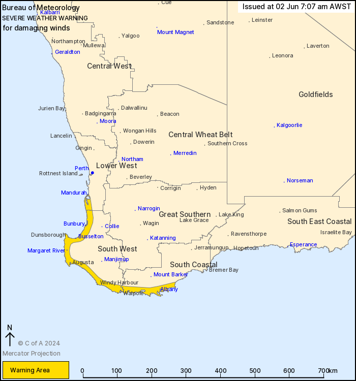
For people in parts of South West, South Coastal and Lower West
districts.
Issued at 7:07 am Sunday, 2 June 2024.
Heavy to intense rainfall has eased, but damaging wind gusts still
remain possible about the southwest coast.
Weather Situation: The cold front which brought severe weather to
parts of the southwest overnight has weakened as it moves inland,
easing severe conditions across much of northern and inland parts
of the South West Land Division. Gusty west to southwesterly winds
are expected to continue about the coastal strip from about
Mandurah to Albany today, persisting the damaging wind gust risk
until later this evening.
West to southwesterly DAMAGING WIND GUSTS up to 90 km/h still
remain possible about the coastal fringe south of Mandurah in the
Lower West and in the South West and South Coastal districts.
Conditions are likely to ease north of Margaret river by late this
afternoon, then easing further along the southern coast later this
evening.
Heavy rainfall and the threat of destructive wind gusts has now
eased across the southwest.
Locations which may be affected include Albany, Bunbury,
Busselton, Mandurah, Margaret River and Walpole.
Severe weather is no longer occurring in the Central West, Great
Southern and Central Wheat Belt districts and the warning for these
districts is CANCELLED.
102km/h wind gust was recorded at North Island at 21:49 WST on
Saturday.
91km/h wind gust was recorded at Garden Island at 22:42 WST on
Saturday.
102 km/h wind gust was recorded at Rottnest Island at 01:00
WST
91km/h wind gust was recorded at Busselton Jetty at 01:31
WST
93 km/h wind gust was recorded at Armament Jetty at 01:26
WST
29.2mm in 30 minutes was recorded at Wilyabrup up to 01:50
WST
54.6mm in 5 hours was recorded at Donnybrook East up to 03:00
WST
The Department of Fire and Emergency Services advises that people
should:
* If outside find safe shelter away from trees, power lines, storm
water drains and streams.
* Close your curtains and blinds, and stay inside away from
windows.
* Unplug electrical appliances and do not use land line telephones
if there is lightning.
* If boating, swimming or surfing leave the water.
* Be alert and watch for hazards on the road such as fallen power
lines and loose debris.
* Keep away from flooded drains, rivers, streams and
waterways.
* Be careful of fallen trees, damaged buildings and debris.
* Be careful of fallen power lines. They are dangerous and should
always be treated as live.
* Assess your home, car and property for damage.
* If damage has occurred take photos and contact your insurance
company to organise permanent repairs.
* If your home or property has significant damage, like a badly
damaged roof or flooding, call the SES on 132 500.
01/Jun/2024 11:30 PM

